Please leave a note on the blog page if you see an error, have information to add, or simply want to ask a question.
There are original document images, transcriptions, and maps linked throughout. Don’t forget to clink on those links!
(Some of the images are LARGE. Be patient … they’re loading. You’ll appreciate the higher resolution.)
Chatham County, North Carolina, Land Patents, Grants and Deeds
| Date | Reference | Grantee | Grantor |
|---|---|---|---|
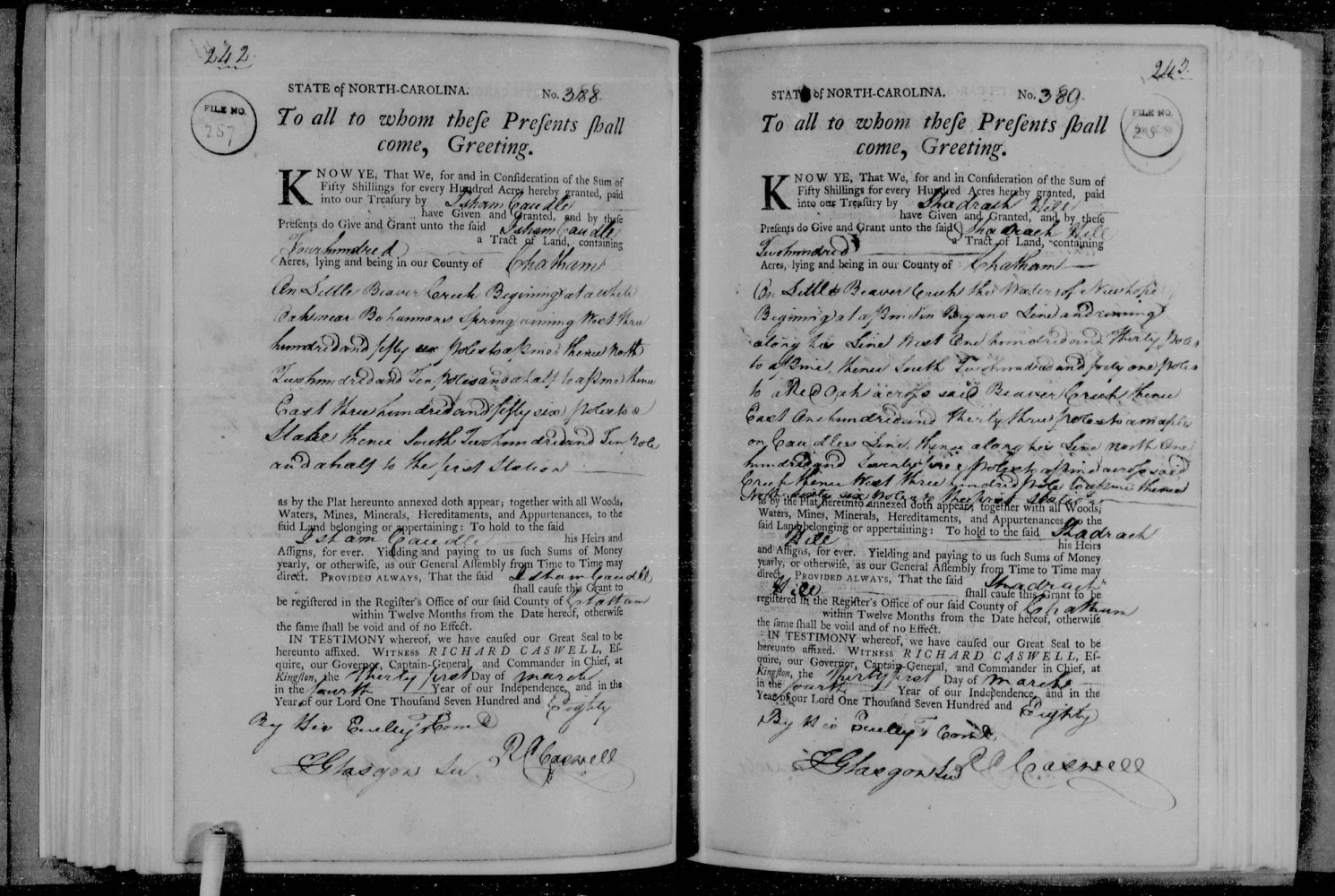
| 1780 | Chatham County Register of Deeds. Book C, p.47 Book C, p.48 State Archives of NC microfilm reel S.108.595, Book 32 p. 242  | Isham Caudle [113] | State of NC |
| Abstract: 400 acres of land to Isham Caudle. Beginning at a WHITE OAK on 'Bohannon's Spring' on Little Beaver Creek W (356 poles) to a PINE; thence, N (210 1/2 poles) to a PINE; thence, E (356 poles) to a STAKE; thence, S (210 1/2 poles) to the P.O.B. Patent #257; Issued: 31 Mar 1780; Grant no.: 388; Entered: 02 Apr 1779; Entry no.: 629 {35°41'08.6"N 78°58'27.9"W} Commentary: 1. There's very little run of Little Beaver Creek in Chatham County. Further, the eastern county line doesn't appear to have moved since being established in 1771; 2. The property being described in this deed is now submerged beneath Jordan Lake. "Constructed at an original cost of US $146,300,000, it is owned and operated by the United States Army Corps of Engineers, which dammed and flooded the Haw River and New Hope River between 1973 and 1983." 3. Mathematically, the area calculates to 468 acres, not 400; |
|||
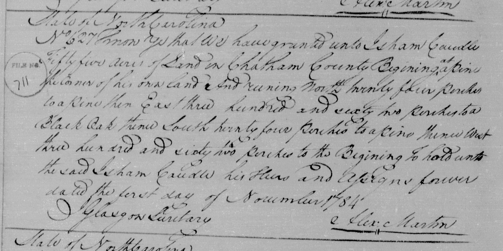
| Nov. 1, 1784 | Chatham County Register of Deeds. Book D, p. 45 Book D, p. 46 State Archives of NC microfilm reel S.108.597, Book 55 p. 68 | Isham Caudle [113] | State of NC |
| Abstract: 55 acres of land to Isham Caudle. Beginning at a PINE, his own corner, thence, N (44 perches) to a PINE; thence, E (362 perches) to a BLACK OAK; thence, S (24 perches) to a PINE; thence, W (362 perches) to the P.O.B. Grant #627; Issued: Mar. 31, 1780; Grant no.: 388; Entered: Oct. 22, 1779; Entry no.: 486 {35°41'08.6"N 78°58'27.9"W} Commentary: 1. The western edge call is 44 perches and the eastern edge call is 24 perches. If the property is 24 perches by 362 perches, then it calculates to 54.3 acres; 2. Perches and poles are synonymous (16 1/2'); 3. See the 1780 Grant for 'his own corner' metes and bounds; 4. The property being described in this deed is now submerged beneath Jordan Lake. "Constructed at an original cost of US $146,300,000, it is owned and operated by the United States Army Corps of Engineers, which dammed and flooded the Haw River and New Hope River between 1973 and 1983." |
|||
| Indenture: November 21, 1785 Recorded: May 1787 | Chatham County Register of Deeds. Book D, p. 261 Book D, p. 262 | John Caudell [14522] | Isom Rodgers |
| Abstract: Indenture made November 21, 1785 between Isom Rodgers of Chatham Co. and John CAUDELL of Cumberland Co. In consideration of sixty-five pounds, Isom Rodgers conveys to John Caudell a 540 acre tract on the east side of Newhope Creek. Beginning at a PINE corner the dividing line between John Hatley, Sr. and William Wilson; thence, run E to a RED OAK; thence, N (284 1/2 poles) to a PINE; thence, W along the line to a PINE; thence, S along the dividing line to the first station (P.O.B.). Isham Rodgers received two land grants, both issued in 1780, one of which is being sold {in part} to John Caudle in 1785. Grant No. 364; 50 shillings per 100 acres; entered Apr. 02, 1779; Entry no.: 499; Issued Mar. 31, 1780; Book: 32 p. 218; (indexed as Isham Robers). 640 acres beginning at a post oak on SYPERT's (?) corner in John Hatley's line; thence, E (360 poles) to a red oak; thence, N (284 1/2 poles) to a pine; thence, W (360 poles) to a stake in Hatley's line; thence, S along his line (284 1/2 poles) to the first station. Grant No. 184; 50 shillings per 100 acres; entered Oct. 22, 1779; Entry no.: 856; Issued Mar. 30, 1780; Book: 36 p. 363. 180 acres on the branches of the New Hope beginning at his own pine corner; thence, N (39 poles) to a stake in {Mark, Maury, Marry} Patterson's line; thence, along his line W (84 poles) to a stake; thence, N (127 poles) to a hickory in Goodwin's line; thence, W along his line (162 poles) to a pine in Rodgers {sic. his own} line; thence, down that line (166 poles) to a pine in his line; thence, E (246 poles) to the first station. (State indexing system references 'Horsepen Branch' and 'Lick Creek' although I see no such call is evident or apparent in the original document). Commentary: 1. John was from the southern neighboring county of Cumberland, not Chatham. Seemingly, John is relocating in November of 1785; 2. Jas. Christian, witness. James Christian appears as a sergeant within the muster roll of Capt. John Birdsong's Company, Sept. 23, 1772; 3. Jacob Rodgers, witness. Jacob 'might' have been Isom's father; 4. Isom Rogers appears on the muster roll of Captain Elisha Cain's Company in 1772; 5. CHATHAM COUNTY, NORTH CAROLINA COURT OF PLEAS AND QUARTER SESSIONS (1774‑1779) p. 179: "The order of the Court be renewed for laying out a road from Orange County line ... crossing the North East branch of new Hope above the mouth ... and that any twelve of the following Persons be a Jury to lay off the same ... James Christian ... Isom Rogers ..." |
|||
| Nov. 1790 | Chatham County Register of Deeds. Book E, p. 81 | Allin Hudson | Isham Caudle [113] |
| Abstract: Indenture made February 11, 1790 between Isham Caudle of Chatham Co. and Allin Hudson of Chatham Co. In consideration of 100 pounds, Isham Caudle conveys to Allin Hudson a 100 acre tract on the north side of waters of Little Beaver Creek. Beginning at a RED OAK corner on Caudle's Line; thence, N course to a BLACK GUM; thence, E course to a BLACK OAK; thence, S course to RED OAK, continue to head of little branch, continue down the branch to a WILLOW OAK on the Great Branch; thence W to the P.O.B. Witnesses: Stephen Wilson; William Rhoades; John Richerson; J. Hudson. Proven during the November Session of 1790. Test. John Ramsey C.C. {Chain Carrier} Commentary: 1. This indenture to Allin Hudson, and the indenture to William Hudson, Jr., {Book E, p.87}, both occurred on the same day, February 11, 1790. Allin Hudson and William Hudson, Jr. were brothers; 2. On Dec. 9, 1794, Allen Hudson sells this property his brother, William Hudson, {Book H, p.44}. Isom Caudle witnessed the sale; 3. Allin's 100 acre tract is north of his brothers 100 acre tract. The properties share the RED OAK corner and WILLOW OAK corner; 4. The property being described in this deed is now submerged beneath Jordan Lake. "Constructed at an original cost of US $146,300,000, it is owned and operated by the United States Army Corps of Engineers, which dammed and flooded the Haw River and New Hope River between 1973 and 1983." |
|||
| Nov. 1790 | Chatham County Register of Deeds. Book E, p. 87 | William Hudson, Jr. | Isham Caudle [113] |
| Abstract: Indenture made February 11, 1790 between Isham Caudle of Chatham Co. and William Hudson, Jr. of Chatham Co. In consideration of 100 pounds, Isham Caudle conveys to William Hudson, Jr. a 100 acre tract on the north side of waters of Little Beaver Creek. Present: Stephen Wilson; William Rhoades; John Richerson; J. Hudson. Proven during the November Session of 1790. Test. John Ramsey C.C. {Chain Carrier} Commentary: 1. This indenture to William Hudson, Jr., and the indenture to Allin Hudson, {Book E, p.81}, both occurred on the same day, February 11, 1790; 2. The property being described in this deed is now submerged beneath Jordan Lake. "Constructed at an original cost of US $146,300,000, it is owned and operated by the United States Army Corps of Engineers, which dammed and flooded the Haw River and New Hope River between 1973 and 1983." |
|||
| May 1791 | Chatham County Register of Deeds. Book E, p. 143 | Buckner Cawdell [12893] | Titus Atwater |
| Abstract: | |||
| Nov. 1794 | Chatham County Register of Deeds. Book G, p. 331 | John Richerson {sic. Richardson} | Isham Caudle [113] |
| Abstract: | |||
| Indenture: Feb. 21, 1795 Recorded: February Session 1796 | Chatham County Register of Deeds. Book H, p. 130 Book H, p. 131 | Thomas Thompson | John Caudle [14522] |
| Abstract: Indenture made February 21, 1795 between John Caudle of Chatham Co. and Thomas Thompson of Orange Co. In consideration of 100 pounds, John Caudle conveys to Thomas Thompson a 200 acre tract on the east side of Newhope Creek. Beginning at a PINE John King's corner run N to a PINE; thence, W to a PINE; thence, S along a row of marker trees John Hartley's line to the Cattail Branch; thence, with the branch as it meanders to a HICKORY and a ELM at the mouth of a branch that comes in on the S side of Cattail branch; thence, up the small branch (40 poles) to a PINE and a MAPLE; thence, E to the P.O.B. Part of a tract of land surveyed by Isham Rogers and conveyed to John Caudle and from him to Thomas Thompson. Present: James Sellars Wiley Griffin {35°36'46.04"N 79° 9'37.35"W} Commentary: 1. See Book D, p. 262 for transaction Isham Rogers 540 acres to John Caudle, 1785; |
|||
| Aug. 1796 | Chatham County Register of Deeds. Book H, p. 227 | Ely Howard | Isham Caudle [113] |
| Abstract: | |||
| May 1798 | Chatham County Register of Deeds. Book J, p. 450 | William Powell | Buckner Caudell [12893] |
| Abstract: | |||
| Feb. 1799 | Chatham County Register of Deeds. Book K, p. 180 | Jesse Caudle [?] | Ely Howard |
| Abstract: | |||
| May 1803 | Chatham County Register of Deeds. Book N, p. 63 | Joshua Caudle [?] | Charles Dowd |
| Abstract: | |||
| Aug. 1806 | Chatham County Register of Deeds. Book O, p. 224 | Prince & Lightfoot | John Caudle [?] |
| Abstract: | |||
| Feb. 1807 | Chatham County Register of Deeds. Book O, p. 146 | Bledsoe Caudle [14517] | John Tedder |
| Abstract: | |||
| 1809 | Chatham County Register of Deeds. Book P, p. 303 | Ransford Mitchell | John Caudle [?] |
| Abstract: | |||
| Feb. 1810 | Chatham County Register of Deeds. Book P, p. 427 | Jesse Caudle [?] | John Richardson |
| Abstract: | |||
| Aug. 1813 | Chatham County Register of Deeds. Book T, p. 61 | William Tucker [?] | Joshua Caudle [?] |
| Abstract: | |||
| Aug. 1814 | Chatham County Register of Deeds. Book T, p. 119 | Isham Codle [?] | Burwell Williams |
| Abstract: | |||
| May 1815 | Chatham County Register of Deeds. Book T, p. 224 | John Caudle [14522] | Willis Wilson [15083] |
| Abstract: 230 acres of land from Willis Wilson [15083] to John Caudle. On the waters of Deep and Rocky Rivers. Begin at Amos Harley's POST OAK then with Harley's line (150 poles) to a STAKE at Bryan's corner; thence, N (250 poles) to a STAKE; thence, W (30 poles) to a DEAD PINE in the head of the DRAIN(?); thence, down the DRAIN to the mouth; thence, down the BRANCH to a SPANISH OAK in Patty's(?) line; thence, E with Bryan's line (140 poles) to a RED OAK; thence, S (260 poles) to the P.O.B. {35°36'46.04"N 79° 9'37.35"W} Commentary: 1. Willis Wilson [15083], was John's brother-in-law, Rebecca's younger brother. After selling this property to John and Rebecca, he departed for Mississippi where he lived the remainder of his years; |
|||
| May 1815 | Chatham County Register of Deeds. Book T, p. 324 | Jessie Caudle [?] | James Tedder |
| Abstract: | |||
| Aug. 1816 | Chatham County Register of Deeds. Book U, p. 277 | James Tedder | Jesse Caudle [?] |
| Abstract: | |||
| Feb. 1818 | Chatham County Register of Deeds. Book V, p. 27 | Jesse Caudle [?] | William Prince |
| Abstract: | |||
| Feb. 1818 | Chatham County Register of Deeds. Book V, p. 53 | William Bridges | Jesse Caudle [?] |
| Abstract: | |||
| May 1819 | Chatham County Register of Deeds. Book W, p. 10 | Alexander Carrew | Jessey Caudle [?] |
| Abstract: | |||
| Aug. 1819 | Chatham County Register of Deeds. Book W, p. 121 | John Morgan | John Caudle [?] |
| Abstract: | |||
| May 1821 | Chatham County Register of Deeds. Book X, p. 282 | John Holleman Jr. | John Caudle [?] |
| Abstract: | |||
| Feb. 1822 | Chatham County Register of Deeds. Book Y, p. 8 | Joseph May | John Caudle [?] by Shff |
| Abstract: | |||
| Aug. 1822 | Chatham County Register of Deeds. Book Y, p. 92 | Samuel Wilson | Isham Caudle [?] |
| Abstract: | |||
| May 1825 | Chatham County Register of Deeds. Book Z, p. 379 | Joseph Hawkins | JNO Caudle [?] |
| Abstract: | |||
| Mar. 11, 1857 | Chatham County Register of Deeds. Book A-K, p. 177 | John Walden | William H. Caudle |
| Abstract: D-T |
|||
| Aug. 1857 | Chatham County Register of Deeds. Book A-K, p. 280 | Mary A. Caudle [?] | Solomon Brown |
| Abstract: | |||
| May 31, 1884 | Chatham County Register of Deeds. Book B-I, p. 56 | Rynum & Headen | A.J. Caudle A.B. Caudle |
| Abstract: Mtge. |
|||
| Sept. 17, 1884 | Chatham County Register of Deeds. Book B-I, p. 300 | S.T. Womble | A.J. Caudle A.B. Caudle |
| Abstract: Mtge. |
|||
| May 15, 1885 | Chatham County Register of Deeds. Book B-N, p. 280 | William Pennington | A.J. Caudle A.B. Caudle |
| Abstract: | |||
| Dec. 31, 1885 | Chatham County Register of Deeds. Book B-O, p. 544 | Ann J. Deserne | David Caudle Mary A. Caudle |
| Abstract: | |||
| Feb. 20, 1886 | Chatham County Register of Deeds. Book B-M, p. 556 | Rynum & Headen | A.J. Caudle A.B. Caudle |
| Abstract: Mtge. |
|||
| Oct. 27, 1886 | Chatham County Register of Deeds. Book B-T, p. 429 | E.C. Poe (et.al.) | A.J. Caudle A.B. Caudle |
| Abstract: Mtge. |
|||
| Jan. 25, 1887 | Chatham County Register of Deeds. Book B-R, p. 462 | Annie B. Caudle (et. al.) | C.B. Poe (Est by Comrs) |
| Abstract: | |||
| Dec. 28, 1891 | Chatham County Register of Deeds. Book C-H, p. 389 | A.J. Caudle A.B. Caudle | E.C. Poe (et. al.) |
| Abstract: | |||
| Feb. 24, 1892 | Chatham County Register of Deeds. Book C-K, p. 329 | W.C. Maxwell Tr. | A.J. Caudle A.B. Caudle |
| Abstract: D-T |
|||
| Jan. 20, 1894 | Chatham County Register of Deeds. Book C-M, p. 577 | Jasper N. Hamlet | A.J. Caudle A.B. Caudle |
| Abstract: | |||
| July 21, 1923 | Chatham County Register of Deeds. Book F-Z, p. 497 | Bank of Goldston | W.C. Caudle Fannie Caudle |
| Abstract: Mtge. |
|||
| Mar. 21, 1923 | Chatham County Register of Deeds. Book F-Y, p. 324 | Fannie Caudle W.C. Caudle | Lawson Fields (et. al.) |
| Abstract: Quit Claim Deed |
|||
| Oct. 10, 1925 | Chatham County Register of Deeds. Book G-K, p. 324 | J.L. Cook | W.C. Caudle Fannie Caudle (et. al.) |
| Abstract: | |||
| Feb. 8, 1926 | Chatham County Register of Deeds. Book G-L, p. 349 | A.C. Ray Tr. | W.C. Caudle Fannie Caudle |
| Abstract: D-T |
|||
| Apr. 23, 1935 | Chatham County Register of Deeds. Book H-R, p. 28 | W.F. Sizemore | W.C. Caudle Fannie Caudle (et. al.) |
| Abstract: | |||