This page was last updated July 25, 2020.
A chronological listing of historical and familial events defined as the Colonial Period occurring after the Early American Period which ended in 1630. The Colonial Period ending is marked by the end of the French and Indian War in 1763.
Please feel invited to leave comments by Writing Home if you see errors or know of a missing event entry that should be included and use citations whenever possible.
Graphic Conventions:
- Important or interesting historical events are included and highlighted in GREEN to assist the reader in establishing a context between the indexed events and our country’s history;
- Persons of interest to the family are highlighted in RED to draw the reader’s attention and facilitate visual scanning of the page;
- Information based upon oral tradition and oral lore is highlighted in YELLOW. Yellow is the color of caution and was used here by no mistake!
See our COLONIAL RECORDS page for events that transpired after 1630.
See our EARLY AMERICA page for events that transpired prior to 1630.
Go to REVOLUTIONARY AMERICA for the period beginning 1764.
RECORD 1634-A
1634
EIGHT SHIRES CREATED IN VIRGINIA. The total population of the colony was approximately 5,000 inhabitants.
“The original Shires of Virginia were:
1. Accomac Shire (now Northampton & Accomack Counties);
2. Charles City Shire (now Charles City County);
3. Charles River Shire (now York County);
4. Elizabeth City Shire (extinct – consolidated with the City of Hampton);
5. Henrico Shire (now Henrico County);
6. James City Shire (now James City County);
7. Warwick River Shire (extinct – consolidated with the City of Newport News);
8. Warrosquyoake Shire (now Isle of Wight County).”
https://en.wikipedia.org/w/index.php?title=Shires_of_Virginia&oldid=688165861
RECORD 1635-A
April 16, 1635
Hotten, John Camden, ed. The original lists of persons of quality; emigrants; religious exiles; political rebels; serving men sold for a term of years; apprentices; children stolen; maidens pressed; and others who went from Great Britain to the American Plantations, 1600-1700 : with their ages and the names of the ships in which they embarked, and other interesting particulars; from mss. preserved in the State Paper Department of Her Majesty’s Public Record Office, England. London, 1874, Reprinted Empire State Book Co., New York, p.67.
William Cawdle, age 19, departed London April 16, 1635, an indentured servant bound for the developing Puritan English colony of Island of Providence.
“THEIS pties hereafter expressed are to be transported to the Island of Providence imbarqued in ye Expectacion CORNELIUS BlLLINGE Mr, having taken the Oaths of Allegeance f Supremacie: As likewise being conformable to the Church of England ; whereof they brought testimonie from the Ministers Justices of Peace, of their Abodes”
NARRATIVE:
1. The Island of Providence is an island in the Caribbean Sea 680 miles south of Havana, Cuba, and approximately 160 miles east of Nicaragua’s eastern shore. The island first became an English Puritan colony (Providence Island Company) in 1629. At the time they arrived, there were Dutch occupants already on the island. By 1631, the English had fully established their colony. Until 1635, wives and children were discouraged on the island. At that time, the island demographics was composed of approximately 500 white men, 40 women, 90 blacks, and very few children.
2. In July of 1635, the Spanish Fleet first anchored off the coast of the island and launched their first attack. The Spanish sought to capture the island from the English. If the date of this record, April 16, 1635, is the date the Expedition departed London, then it’s quite likely that William Cawdle was an arriving at the island just as the Spanish were attacking;
RECORD 1637-A
April 13, 1637
Nugent, Nell Marion. Cavaliers and Pioneers: Abstracts of Virginia Land Patents and Grants, 1623-1666, Vol. 1. Richmond [VA]: Dietz Printing Co., 1934. 767p. Reprinted by Genealogical Publishing Co., Baltimore, 1983. p. 55. [Dewey 929.3 Nv]
Patrick Kennede, 600 acs. In the Upper Co. of New Norfolk, 13 April 1637, p.415. On the W. br. Of Eliz. Riv., butting on the maine river running S. S. W. & on the maine br. To the Swd. Running W. N. W. on Kennedeyes Cr. &c. Trans. of 12 pers: Patrick Kennede, Edmund Camell, Robert Perry, Phillipp Caudell (or Candell), John Waters, Robert Greene, Arthur Taylor, Harman Turner, Jerimiah Ward, Henry Bayle, John Garye, Tho. (first written Charles) Hayes. Note: Renewed in the name of Jonathon Langworth, Chirurgion & 600 acs. added.
NARRATIVE:
1. Phillip Caudell was likely an indentured servant. No further Record;
2. Patrick Kennede was a mariner and perhaps a Master. I find his name associated with a sailing of the Marmaduke in 1627 from Cowes, England, as well as the sailing of the Friendship from Poole, England, 1629. (Virginia Immigrants and Adventurers, 1607-1635: A Biographical Dictionary);
3. The surname Kennede is likely Irish or Scottish origin although he’s associated with English sailing ships. The other surnames such as Perry and Taylor are primarily English in origin;
4. Patrick Kennede may have been one of the first Kennedy’s in America;
5. Knowing that Kennede’s land was on the west branch of the Elizabeth River, we deduce this property was in present day Portsmouth, VA: N360 50′ 48.03″ 760 21′ 57.43″W.
MAPS & DOCUMENTS:
p.55
RECORD 1637-B
April 22, 1637
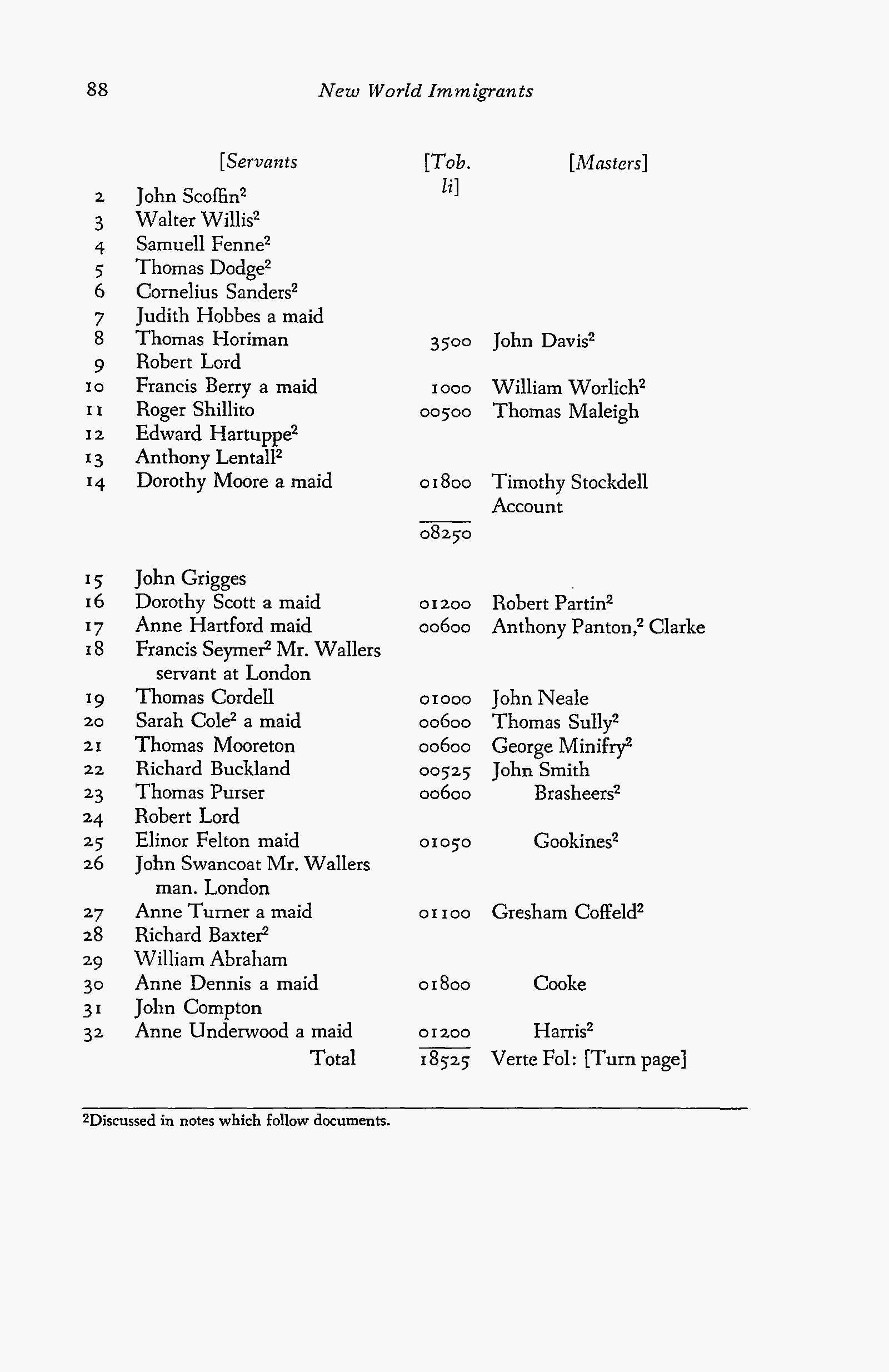
Tepper, Michael. NEW WORLD IMMIGRANTS: A Consolidation of Ship Passenger Lists and Associated Data from Periodical Literature. Volume 1. Baltimore [MD]: Genealogical Publishing Co., Inc., 1979, p. 88.
Thomas Cordell, immigrant aboard the Tristram and Jeane bound for VA from London; Daniell Hopkinson, merchant; Joseph Blowe, master. Thomas Cordell was a servant bound to John Neale, master, for 1,000 Tobacco libra pound.
NARRATIVE:
1. It’s a curious thing that Phillip Caudell {Record 1637-A}, also an indentured servant, arrived eight days prior to Thomas Cordell;
2. This record states that the ship departed London removing any speculation regarding Thomas’ point of departure;
3. It is likely, (not affirmed), that John Neale resided in Northampton Co., VA.
4. John Neale was a ship’s captain and owned substantial tracts of land in Accomack, VA, Smith’s Island (37° 8’38.51″N 75°52’10.73″W):
– 1,500 acs. Accomack Co., June 18, 1636; trans. of 30 persons (named);
– 500 acs. Accomack Co., May 18, 1637, trans. of 10 persons (named);
– 200 acs. Accomack Co., August 22, 1637, trans. of 4 persons (named);
ACCOMPTS of the TRISTRAM and JANE, Martha W. Hiden, The Virginia Magazine of History and Biography, Vol. 62, No. 4 (October, 1954), pp. 424-447.
ACCOMPTS {sic. ACCOUNTS} of the TRISTRAM and JANE, A Booke of Accoumpts for the Shippe called the Tristram and Jeane of London which came from Virginia Anno Domini 1637, Exhibit 26th Aprilis 1637.
Thomas Cardwell Sr. was the son of William Cardwell (1590-1660) & Mary Wiltshire (1592-1662) of Kirkham, Lancashire, England (who later moved to Thornhill Parish, Yorkshire, England). Thomas immigrated to Virginia Colony in 1636 at age 21 on the ship “Tristram & Jane” and settled in King William Co., Virginia. Thomas first married Grace Carey Spencer (1615-C1646) from Shropshire, England in 1638 in King William Co., Virginia. It is unknown if Thomas & Grace had any children there. After Grace’s death, Thomas married Mary Elizabeth Collyer (1615-c1698) from Wilshire, Shropshire, England on April12,1660 in Middlesex Co., Virginia. Thomas and Mary had at least six children, four of whom lived to adulthood. They were: Thomas Jr. Cardwell (1660-1717), Mary Nora Cardwell Masey (1662-??), Penelope Cardwell Basket (1663-??) and Ann Cardwell Basket (1665-??). Sons Richard & William both died young. Thomas’s will was dated May 12,1687 & proven on July 6,1689. He died shortly after his will and was buried in the Old Christchurch Parish Churchyard in Middlesex Co., Virginia. Mary Elizabeth married again a John Williams on October10,1696 in Middlesex Co., Virginia. Thomas Cardwell was the first of the Cardwell Line to immigrate to the New World.
The will of Thomas Cardwell Sr. of Middlesex Co., VA dated May 12, 1687 and recorded July 6, 1689 leaves his plantation to his wife Mary and his two minor daughters, Ann and Nora Cary. Mentioning sons-in-law Thomas and John BASKET and appointing his son-in-law Raleigh Masey as executor, and Thomas Jr. and Job Richards as overseers of the will.
MAPS & DOCUMENTS:
p.88
RECORD 1638-A
April 24, 1638
Cottle William aboard “Confidence” 1638
ISTG Home Page
Immigrant Ships, Transcribers Guild, “Confidence”
Southampton, England to New England
List of passengers from Southampton for New England 24 April 1638 by the ‘Confidence’ of London, two hundred tons – Master Mr. John Gibson.
“by vertue of the Lord Treasurers warrant of the 11th April”
John Sanders, 25, of Langford, Wilts, husbandman, Settled Salisbury
Accompanied by:
his wife: Sara
? relationship: John Cole 40
servants: Roger Eastman 25
Richard Blake 16
William Cottle 12
Robert King 24
Abt. 1652
SURRY COUNTY VIRGINIA FORMED from James City.
RECORD 1654-A
December 6, 1654
1. Library of Virginia – Land Office Patents. No. 3, 1652-1655, p. 309-310. (LOV ~ REEL #2).
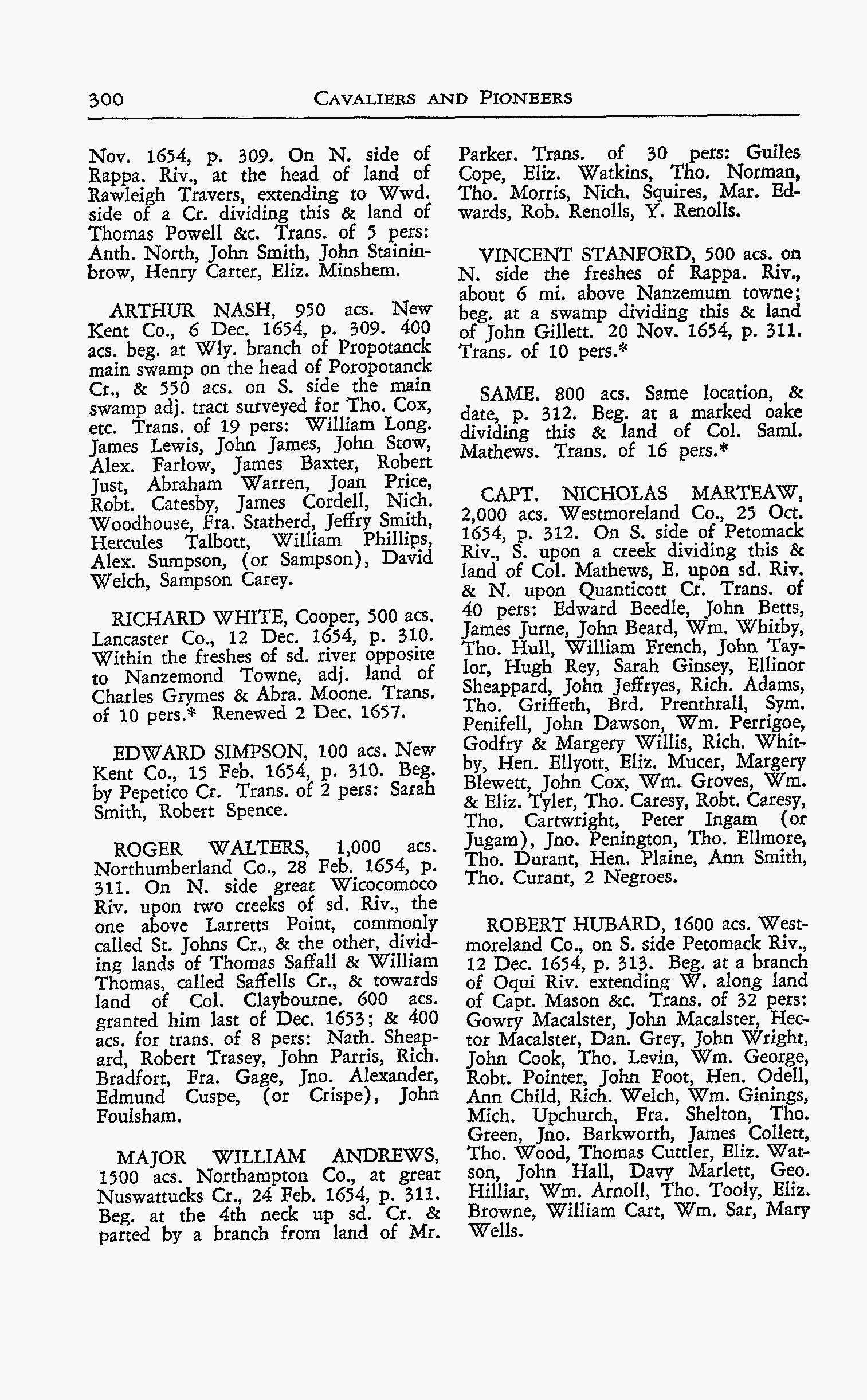
2. Nugent, Nell Marion. Cavaliers and Pioneers: Abstracts of Virginia Land Patents and Grants, 1623-1666, Vol. 1. Richmond, VA.: Dietz Printing Co., 1934. 767p. Reprinted by Genealogical Publishing Co., Baltimore, 1983. p. 300. [Dewey 929.3 Nv]
Arthur Nash, New Kent Co., VA., 950 acs. for the transportation of 19 persons. 400 acs. beg. at Wly. branch of Propotanck main swamp on the head of of Poropotanck Cr. & 550 acs. on S. side of the main swamp adj. to tract surveyed for Tho. Cox. Trans. of 19 pers: William Long, James Lewis, John James, John Stow, Alex Farlow, James Baxter, Robert Just, Abraham Warren, Joan Price, Robt. Catesby, James Cordell, Nich. Woodhouse, Fra. Statherd, Jeffry Smith, Hercules Talbott, William Phillips, Alex. Sumpson. (or Sampson), David Welch, Sampson Carey.
NARRATIVE:
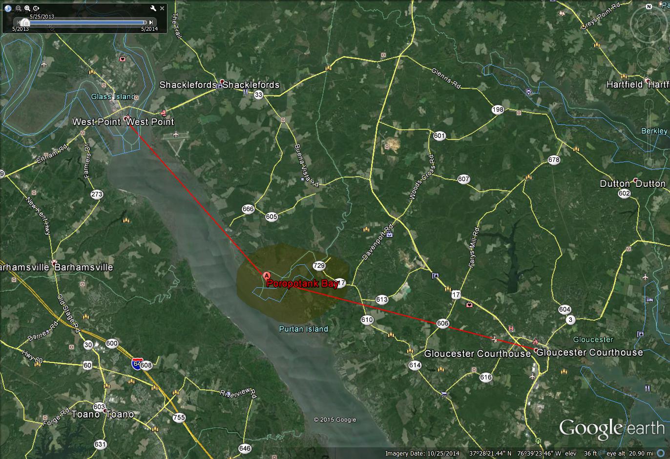
1. The Poropotank Bay meets the York River at Latitude: N370 26′ 41.32″ 760 41′ 56.01″W;
2. James Cordell was likely an indentured servant. No further Record;
3. The Poropotank Bay is 10 mi. west of Gloucester Courthouse and 8 mi. southeast of West Point, VA. and the Port of Richmond;
4. The Mattaponi and Pamunkey Rivers join in West Point to form the York River;
5. In a New Kent Co. VA Land Grant November 1682, William Lines,(VA Patents Book 7, p. 202), William Lines two hundred and thirty acs. of land lying in New Kent Co., joining to a branch of Poropotank Creek. That land bounded in part by land of Arthur Nash, e.g.
MAPS & DOCUMENTS:
Cavaliers and Pioneers, p.300
LOV, Patent Book 3, pp. 309 – 310
RECORD 1656-A
December 8, 1656
1. Library of Virginia – Land Office Patents. No. 4, 1655-1664, p. 66. (LOV ~ REEL #4).
2. Nugent, Nell Marion. Cavaliers and Pioneers: Abstracts of Virginia Land Patents and Grants, 1623-1666, Vol. 1. Richmond [VA]: Dietz Printing Co., 1934. 767p. Reprinted by Genealogical Publishing Co., Baltimore, 1983. p. 334. [Dewey 929.3 Nv]
Henry Chichley, Knt., 2,200 acs. On N. side of Rappa Riv., opposite to Port Tobacco, bounded on E. with Poytresses Cr. & land of Vincent Stanford, etc. 8 December 1656, p. 43, (66). Trans. of 44 pers: Rich. Scarbrow, Tho. Ap Thomas, James Howard, Anthony Caudell, Tho. Beardwell, Rob. Hane (or Hand), Jno. White, Jno. Ray, Henry Rice, Arthur Chandler, Wm. Byler, Wm. Chelmedge, Rich. Arrundell, Tho. Mason, George Haynes, Sam. Parry, Tho. Pones, Peter Mason, Wm. Hutt, Tho. Howell, Samll. Goodwin, Tho. Harris, Rob. Taylor, Tho. ap Richd., Jones Alpott, Jno. Woodson, Edwd. Buckingham, Edward Freeman, Henry Lambert, Jost Wms. (Williams), Tho. Warrington.
NARRATIVE:
1. Antho. Caudell was likely an indentured servant. No further Record. The surname Alpott, (Alport today), is English in origin;
2. Sir Henry Chicheley (1614-1683) was the Lancaster Co. representative in the House of Burgesses, 1656; a member of the Governor’s Council (1670-1683); and Lt. Governor of the Virginia Colony (1678-80 and 1680-1682);
3. Sir Henry Chicheley was born in England and educated at Oxford. During the English Civil Wars (1642–1651) he was a Royalist (“Cavalier”) which ultimately led to his conviction and imprisonment. He was paroled to the colony of Virginia by Order of the Council of State, April 6, 1650 (Interregnum Entry Book, Vol. 132, p.8). Upon his arrival in the colony, or shortly thereafter, he took up residence as a guest with Ralph Wormeley and his wife Agatha Eltonhead Stubbins Wormeley. Ralph Wormeley died in 1651;
4. Chicheley married Agatha Eltonhead Stubbins Wormeley sometime after May 31, 1652, and took up residence at Rosegill, Ralph Wormeley’s plantation. Rosegill is located at the head of Urbanna Creek at Rappahannock River;
5. Upon his arrival in the colony, Sir Henry Chicheley befriended Governor Sir William Berkeley;
6. “He acquired additional land elsewhere in the Rappahannock River basin, all of which, because he had no children, eventually passed to his widow’s son, Ralph Wormeley (1650-1701)”;
7. “Sir Henry Chicheley represented Lancaster Co. in the House of Burgesses in 1656 and not long thereafter, in violation of his parole, returned to England …” Chicheley was returning to England at the same time as he was being patented 2,200 acres of land, and seemingly, 44 indentured servants. He remained in England until 1662;
8. Did Sir Chicheley trade or sell his indentures before going to England for six years?
MAPS & DOCUMENTS:
Cavaliers and Pioneers, p. 334
LOV, Patent Book 4, p. 66.
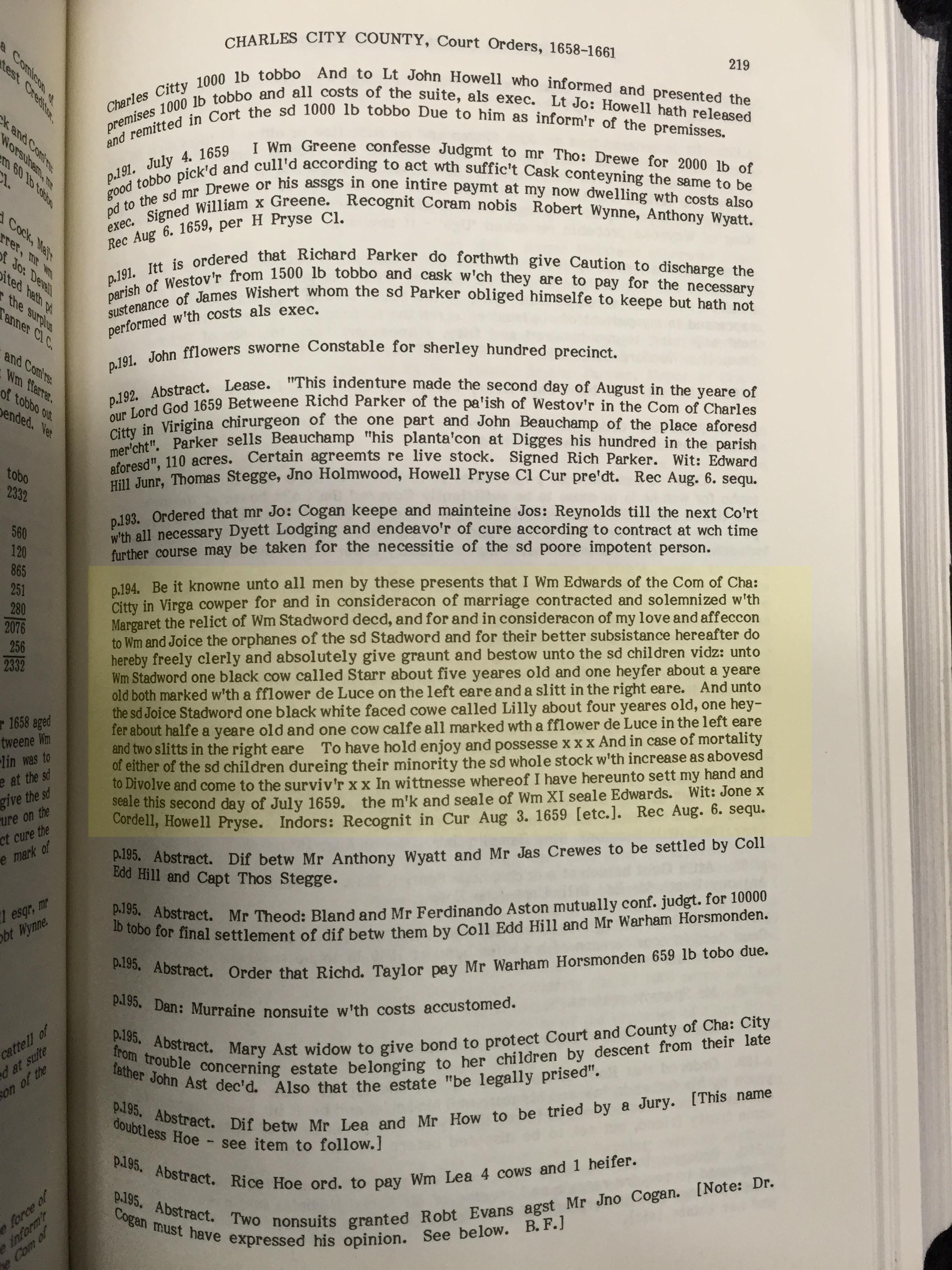
RECORD 1659-A
July 2, 1659
Fleet, Beverly. Virginia Colonial Abstracts, The Original 34 Volumes Reprinted in 3, Vol. III. Baltimore: Genealogical Publishing Co., Inc., 1988, p. 219.
Charles City Co., Court Orders, 1658-1661, p. 194:
“Be it knowne unto all men by these presents that I Wm Edwards of the Com of Cha: City in Virga cowper for and in consideracon of marriage contracted and solemnized w’th Margaret the relict of Wm Stadword dec’d, and for and in consideracon of my love and affeccon to Wm and Joice the orphanes of the sd Stadword and for their better subsistence hereafter do hereby freely clerly and absolutely give graunt and bestow unto the sd children vidz: unto Wm Stadword one black cow called Starr about yeares old and one heyfer about a yeare old both marked w’th a fflower de Luce on the left eare and a slitt in the right eare. And unto the sd Joice Stadword one black white faced cowe called Lilly about four yeares old, one heyfer about halfe a yeare old and one cow calfe all marked wth a fflower de Luce in the left eare and two slitts in the right eare. To have hold enjoy and possesse xxx And in case of mortality of either of the sd children dureing their minority the sd whole stock w’th increase as above sd to Divolve and come to the surviv’r xx In witnesse whereof I have hereunto sett my hand and seale this second day of July 1659. the m’k and seale of Wm XI seale Edwards. Wit: Jone x Cordell, Howell Pryse. Indors: Recognit in Cur Aug 3 1659 [etc.]. Rec August 6 sequ.”
NARRATIVE:
MAPS & DOCUMENTS:
p. 219
Abt. 1680
By tradition, Stephen Cawdle, (Caudill), was born.
RECORD 1682-A
February 28, 1682 / 1683
Library of Virginia – Land Office Patents. No. 7, 1679-1689 (v.1 & 2 p.1-719), p. 233. (LOV ~ REEL #7).
Mason, Polly Cary. Records of Colonial Gloucester County, Virginia: A collection of abstracts from original documents concerning the lands and people of Colonial Gloucester County. Vol. I & II, p. 58.
Nugent, Nell Marion. Cavaliers and Pioneers: Abstracts of Virginia Land Patents and Grants. Vol. 2: 1666-1695. Indexed by Claudia B. Grundman. Richmond, VA: Virginia State Library, 1977. 609 p.
To Major Robert Peyton, 150 acs. in Gloucester Co., VA., (now Mathews Co., VA.), for the transportation of three persons to the colony.
Description: “… unto Robert Peyton of the County of Gloucester Gent. one hundred and fifty acres of land lying in the parish of Kingston in the said County … the land formerly belonging to Mr. Edmund Walsh lying on the north side of Blackwater Creek …”
Headrights: Augustine Caudle, Thomas Roe, Jeffery Hardle.
NARRATIVE:
1. Augustine Caudle was an indentured servant. No further Record.
2. The mouth of Blackwater Creek is located on Mobjack Bay at Latitude: N370 25′ 13.53″ 760 24′ 14.91″W.
3. Blackwater Creek is 8.25 miles due west of the Atlantic Ocean and 6.76 miles east-north-east of Gloucester Courthouse.
4. Robert Peyton was born in Norfolk Co., England. He is thought to have come from England to Gloucester VA sometime around 1679. “Until the later thirteenth century the Peytons were based in southern Suffolk, but the marriage of Thomas Peyton in 1484 to a Cambridgeshire heiress saw the family establish their principal seat at Isleham, just across Suffolk’s western border.” (http://www.historyofparliamentonline.org/volume/1604-1629/member/peyton-sir-john-1561-1616).
5. When Robert Peyton established his plantation in the colony, he too chose the name Isleham. The plantation was located very near the red pin on the map figure below. “Isleham was named for the original Peyton estate in Cambridge, England. It is bounded today by the Blackwater and Hampton Creeks in Mathews. The original Peyton house or houses are gone, but a brick house survives which is thought to have been built by later owners about 1850.” (http://articles.dailypress.com/1996-05-19/news/9605170218_1_county-manager-sir-john-peyton-house).
MAPS & DOCUMENTS:
LOV, Patent Book 7, p. 233

RECORD 1691-A
October 20, 1691
Library of Virginia – Land Office Patents. No. 8, 1689-1695, p. 191. (LOV ~ REEL #8).
Fleet, Beverly. Virginia Colonial Abstracts, The Original 34 Volumes Reprinted in 3, Vol. II. Baltimore: Genealogical Publishing Co., Inc., 1988, p. 404.
Seemingly, Benjamin Clements and James Cawdle are selling 499 acs. of land in King & Queen Co. to William Cardwell and William Fenney. Clements and Cawdle received the 499 acs. of land from William Sawyer who was patented 550 acs. of land April 16, 1633.
“Book 8. p.190. William Cardwell and William Fenney. 20 October 1691. 499 acs. lying on the North side of Mattapony River, at time of survey in New Kent County but now King and Queen. Formerly granted to Wm Sawyer on 16 April 1633 for 550 acres ‘but no more to be found than above is Expressed’, and by said Sawyer sold to Benj Clements and Mr. James Cawdle and by them sold to said Cardwell and Fenney. Adjoins Pauleatt branch, Thos Meade’s line, ‘Thomas Brownes Just over the bridge branch’, a corner tree supposed to be Thomas Maconees, land of Eapharaim Royes, land of Mr Henry Biggs [possibly Pigg], a slash by Mr Bird’s road, corner oak of George Light’s and along his line to Nicholas Ware’s.”
NARRATIVE:
1. Based upon unsubstantiated information, Benjamin Clements was born abt. 1650 in Gloucester, VA., and died abt. June 1721 in Surry, VA. He married Judith Parker, daughter of Richard Parker, and they had at least one child, William Clements, born abt. 1670 in Gloucester, VA.;
2. In a land grant January 3, 1679, New Kent Co., grantee William Sawyer of Gloucester Co., planter, son, and heir of William Sawyer {deceased} is receiving 850 acs. of land on the south side of Peanketauk Swamp. (Library of Virginia – Land Office Patents. No. 7, 1679-1689 (v.1 & 2 p.1-719), p. 18, [Reel 7]).
MAPS & DOCUMENTS:
p. 191.
RECORD 1691-B
1691
Benjamin Harrison III purchased part of Berkley Hundred from Giles Bland. The land became the site of Berkley Plantation, a 1,000 acre plantation on the James River Charles City County, VA. Benjamin Harrison IV built the mansion which was completed in 1726. Several generations of Harrison’s lived at Berkley Plantation. The site is touted as the place of the first official Thanksgiving held on December 4, 1619. Benjamin Harrison III served as the colony’s Attorney General, Treasurer, and Speaker of the House of Burgesses.
NARRATIVE:
1. Berkley Plantation, 12602 Harrison Landing Road, Charles City, VA, 23030.
Latitude: 37.317N, Longitude: -77.180W.
2. Berkley Plantation is located upon the bank of the James River, 22 miles WNW of Jamestown, 20 miles SSW of Richmond, and 12 miles NE of Petersburg.
RECORD 1700-A
April 25, 1700
Library of Virginia – Land Office Patents. No. 9, 1697-1706 (v.1 & 2 p.1-742), pp. 329-330. (LOV ~ REEL #9).
To Colonel Benjamin Harrison, 350 acres on the south side of the main Blackwater Swamp for the transportation of seven to the colony.
{1}: Beginning south side of maine black water, mouth of Indian spring branch; {2}: up the branch into the woods S 192 P to a shrubby black oak; {3}: thence W 278 P to a gum and white wood at a small branch; {4}: down the branch N 26d W 21 P to a pine in the branch; {5}: thence down various courses of the branch to the maine black water swamp; {6}: down the various courses to the first station.
NARRATIVE:
1. Provided the date of 1700, the Benjamin Harrison receiving property here was in all likelyhood Benjamin Harrison III, (b.1673-d.1710). BENJAMIN HARRISON OWNED LARGE TRACTS OF LAND THROUGHOUT SOUTHEAST VIRGINIA. “The Harrison family is a prominent political family in U.S. history. Most famously, this family produced numerous Governors of Virginia (serving during both the Colonial era and after independence), as well as two U.S. Presidents: William Henry Harrison and Benjamin Harrison.” (Wikipedia).
2. Blackwater Swamp today is located in Prince George County, Latitude: 37.1018166, Longitude: -77.1427468.
3. Benjamin received 350 acres for transporting 7 persons, therefore, 50 acres per head.
MAPS & DOCUMENTS:
Original Patents p.329 and p.330.
RECORD 1700-B
April 25, 1700
Library of Virginia – Land Office Patents. No. 10, 1710-1719, p. 348. (LOV ~ REEL #10).
To Benjamin Harrison of Charles City, for the transport of thirty-one persons (named), 1,530 acres on the South side of Nottaway River. Beginning and extending in the north side of the Hunting Quarter Swamp, a little below some Indian old fields.
NARRATIVE:
1. Benjamin Harrison III, fathered a son in 1700, Benjamin Harrison IV. This Benjamin was known as Colonel Benjamin Harrison.
RECORD 1700-C
April 24, 1700
Library of Virginia – Land Office Patents. No. 9, 1697-1706 (v.1 & 2 p.1-742), pp. 259-260. (LOV ~ REEL #9).
To Benjamin Harrison, 115 acres in the upper parish of Surry Co. Adjoins home of William Lewcost, land of William Carpenter, and his own.
RECORD 1702-A
Abt. 1702
PRINCE GEORGE COUNTY VIRGINIA FORMED from Charles City.
RECORD 1703-A
April 24, 1703
Library of Virginia – Land Office Patents. No. 9, 1697-1706 (v.1 & 2 p.1-742), pp. 720-721. (LOV ~ REEL #9) .
To Thomas Pettis, 36 acres of land in St. Stephen’s Parish, King & Queen Co., included by the land of Capt. Wm. Smith, James Caudle, and Thomas Domox.
NARRATIVE:
1. In 1703, one James Caudle is located in King & Queen Co.
RECORD 1704-A
The Virginia Magazine of History and Biography, Vol. 32, p.147. Virginia Quit Rent Rolls, 1704, King & Queen County, 1704/05.
Clerk and Cordell (both in Gloucester) 1,000 acs land holdings in King& Queen, 1704.
NARRATIVE:
During the colonial period land owners in Virginia paid the King “Quit Rent” annually. The price was one shilling for every fifty acres of land.
The list of land owners, and the amount each owned, was prepared by the sheriff of the various counties and delivered to the Receiver-General, who collected the quit rents and transmitted the lists, with his accounts, to the English government.
RESEARCH NOTE:
DOCUMENTS:
Title Page
Page 147
RECORD 1704-B
Wertenbaker, Thomas J. The Planters of Colonial Virginia. (Princeton: Princeton University Press, 1922), p.234.
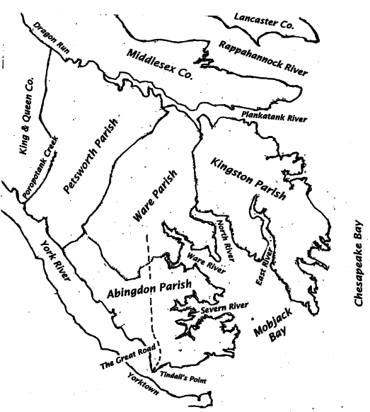
Gloucester Rent Roll, A Rent Roll of Abbington Parrish. Gloucester Co. first appears in “Hening’s Statutes” in a list of Burgesses, at the April 1652 session of the assembly.
Ware Parish served Gloucester County from abt. 1652 until after 1758;
Kingston Parish served Gloucester County from abt. 1652 until after 1758;
Petso Parish is presumably Petsworth Parish.
Richard Cordell appears to be sheriff and reporting the quit rents for these parishes.
| page | Name | Shilling | County |
| 183 | Thos. Cardwell | 350 | Henrico Co. |
| 200 | Thos. Corbell | 200 | Nansemond Co. |
| 202 | Thos. Cottell | 200 | Norfolk Co. |
| 216 | Richard Cotrell | 200 | Kent Co., parrish of St. Peters & parrish of St. Pauls |
| 221 | Richard Codell | 100 | Charles City Co. |
| 226 | Clerk and Cordell
both in Gloucester |
1000 | King & Queen Co., Robt. Bird Sheriff |
| 230 | Benj. Clements | 400 | Gloucester Co., Petso Parrish |
| 234 | Benj. Clements | 500 | Gloucester Co., Abbington Parrish |
| 234 | Richard Cordell
|
Sheriff reporting three parishes for
Gloucester Co. |
Ware 31,603
Petso 41,123 Kingston 46,537 147,698 |
NARRATIVE:
During the colonial period land owners in Virginia paid the King “Quit Rent” annually. The price was one shilling for every fifty acres of land.
The list of land owners, and the amount each owned, was prepared by the sheriff of the various counties and delivered to the Receiver-General, who collected the quit rents and transmitted the lists, with his accounts, to the English government.
RESEARCH NOTE:
(1) See Record 1654-A: James Cordell, indentured servant arrives in this area;
(2) See Record 1691-A: In 1691, Benjamin Clements and James Cawdle are selling 499 acres of land to William Cardwell and William Fenney. Benjamin Clements appears within this 1704 quit rent roll, 13 years later, owing 500 shilling. William Sawyer, also mentioned in the 1691 transaction, appears within this 1704 quit rent roll, 13 years later, owing 150 shilling;
DOCUMENTS:
RECORD 1706-A
May 1, 1706
Library of Virginia – Land Office Patents. No. 9, 1697-1706 (v.1 & 2 p.1-742), pp. 720-721. (LOV ~ REEL #9) .
To Benjamin Harrison of Surry Co., 1,000 acs. on the S side the main Blackwater swamp in the upper parish of the county. Beginning at the mouth of a branch that runs through the old Nottaway Towne. For the transportation of twenty persons to the colony.
NARRATIVE:
1. Blackwater Swamp today is located in Prince George County, Latitude: 37.1018166, Longitude: -77.1427468.
RECORD 1706-B
June 10, 1706
Library of Virginia – Land Office Patents. No. 9, 1697-1706 (v.1 & 2 p.1-742), pp. 740-742. (LOV ~ REEL #9).
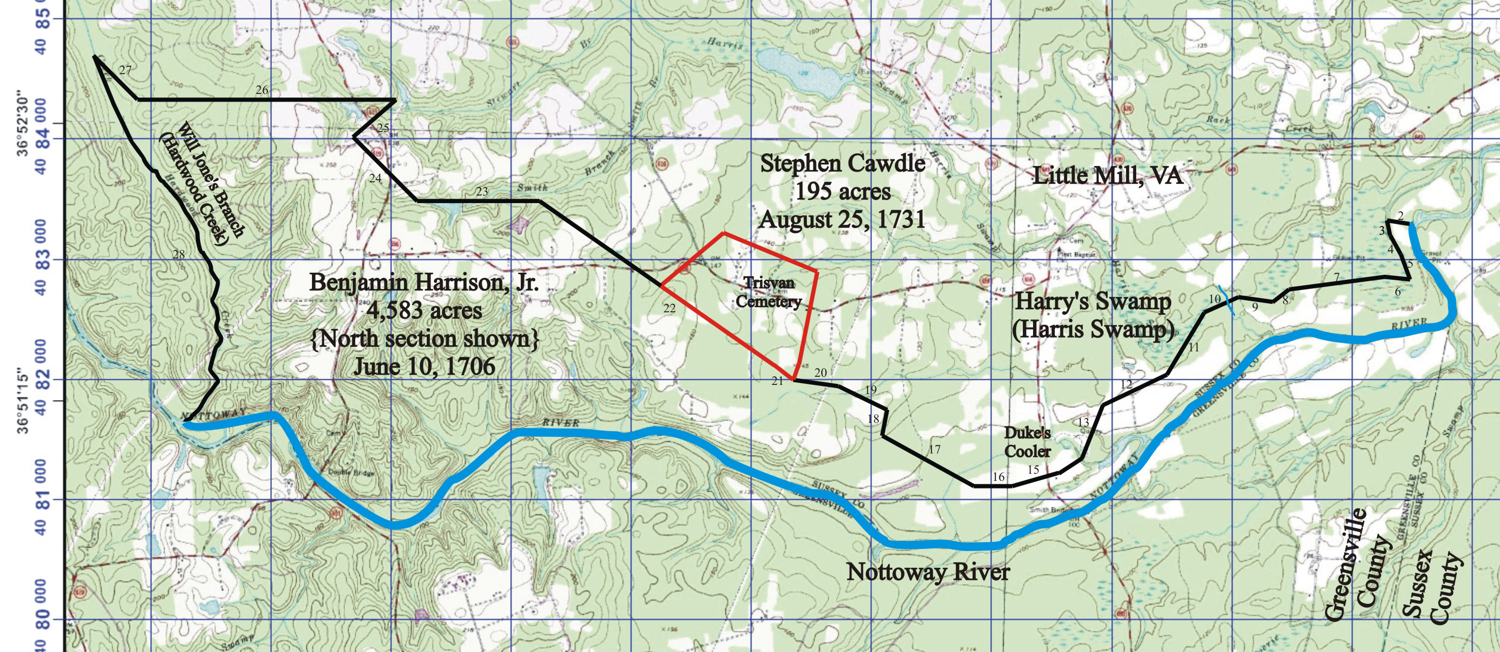
To Benjamin Harrison, Jr. gentleman, 4,583 acs. on both sides of the Nottoway River, Prince George Co., for the transportation of ninety-two persons to the colony (some listed).
Beginning on the north bank of the river, across Harry’s Swamp, to Duke’s Cooler (meadow), to Jone’s Branch, meander to Nottoway River, then to Ruin Spring Branch (?), then to Cheteckcaurah Creek(?).
NARRATIVE:
1. This is likely Benjamin Harrison III (1683-1710);
2. Stephen Cawdle’s Patent of 195 acs. (1731) abuts this property. See the MAP link below;
3. Harry’s Swamp, today Harris Swamp, is located in Sussex Co., at Latitude: 36.809, Longitude: -77.48584.
MAPS & DOCUMENTS:
Original Patents p.740, p.741 and p.742.
RECORD 1707-A
1707
Records of Colonial Gloucester County, Virginia.
Gloucester Town 1707 – The Lotts and Streets first laid out in the Town were thus distinguished: #25 James Caudle.
NARRATIVE:
1. In 1707, one James Caudle is located in Gloucester Town.
RECORD 1711-A
April 28, 1711
Nugent, Nell Marion. Cavaliers and Pioneers: Abstracts of Virginia Land Patents and Grants, 1623-1666. Vol. 3. Virginia State Library, 1979, p. 116. [Dewey 929.3 Nv].
Capt. Francis Morse, 752 acs., (N. L.), Pr. Anne Co.; called Surry Plantation; 28 April 1711, p. 19. Beg. By Pine Island Cr.; by side of Robert Ward’s dwelling house; on James Peters’ patent; to Thomas Walston’s cor; to the head of Caryes Cr; to Thomas Ivye’s ditch; to Dead Ceder Cr; to Back Bay, alias Corotock Bay; a Cr. dividing this from marsh of Maj. Henry Spratt; & another Cr. dividing this from marsh of William Capps, N’ly. out of Corotock Bay, commonly called Pine Island, alias Wickers, Cr. 200 acs. part granted Thomas Griffin, 26 September 1674. Imp. of 11 pers: Temperence Hunt, Eliza. Legg, Penelope Lockard, John Doyle, William Rudd, Mary Rudd, William Henry Rudd, Alice Atherton, Wm. Vane, Margaret Beard, John Caudall (or Candall).
NARRATIVE:
1. What is now Currituck Sound, Currituck Co., NC, was once part of Princess Anne Co., VA.
2. John Caudall was likely an indentured servant. No further Record.
RECORD 1720-A
November 2, 1720
Hening, William Waller. The Statutes at Large; Being a Collection of all the LAWS OF VIRGINIA, from the FIRST SESSION of the LEGISLATURE in the year 1619. Published Pursuant to an Act of the General Assembly of Virginia, passed on the Fifth Day of February, One Thousand Eight Hundred and Eight, Volume IV. Printed for the Editor at the Franklin Press — W.W. Gray, Print., 1820, pp. 77-79.
At A General Assembly Begun and Holden At
The Capitol, in the City of Williamsburg, on the second
day of November, in the seventh year of the reign of
our sovereign Lord George the first, by the grace of
God, of Great Britain, France, and Ireland, King,
defender of the faith, &c.; and in the year of our
lord, 1720.
CHAP. I
An act of erecting the Counties of Spotsylvania and Brunswick; and granting certain exemptions and benefits to the inhabitants thereof.
Preamble …
Brunswick county, beginning on the south side the river Roanoke, at the place where the line lately run for ascertaining the uncontroverted bounds of this colony towards North Carolina, intersects the said river Roanoke, and to be bounded by the direction of the governour with consent of council, so as to include the southern pass; which land from and after the time that it shall be laid off and bounded, shall become a county by the name of Brunswick county.
…
That five hundred pounds be paid by the treasurer to Nathaniel Harrison, esq., Jonathon Allen, Henry Harrison, & William Edwards, gentlemen, or the survivors of them, or in case of their refusal, to such others as the governour shall name, to make up the like number, to be by them laid out for a church, courthouse, prison, pillory and stocks, where they shall think fit, in the county of Brunswick, and are required to account to the general assembly.
Inhabitant of the said counties are made free of publick levies for ten years, from the first of May, 1721.
The whole county of Spotsylvania made one parish, by the name of St. George; and that of Brunswick one, by the name of St. Andrew.
…
CHAP. II
An act for the better discovery and securing of his Majesty’s quit-rents.
Every Sheriff, at November Court, yearly, is to divide his county into precincts, appoint and publickly certify one place in each precinct, which shall not exceed ten miles in distance from the house of any inhabitant of that precinct, and to set the times of his attendance there before the 20th February, annually.
NARRATIVE:
Abt 1720
By tradition, James Caudill, Sr. was born in Virginia.
Abt. 1722
By tradition, Sampson Caudill was born in Virginia.
Abt. 1724
By tradition, William Caudill was born in Virginia.
Abt. 1725
By tradition, Benjamin ‘Benjamin of Sussex’ Caudill born in Virginia.
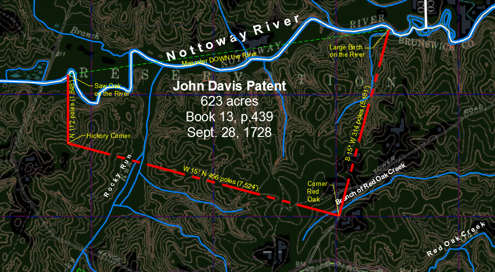
RECORD 1728-A
September 28, 1728
Library of Virginia – Land Office Patents. No. 13, 1728-1732 (pt.1 & 2), p. 429. (LOV ~ REEL #11).
Patent 623 acs. of New Land in Brunswick Co. by George the Second to John Davis on south side of Nottoway River on both sides of the Rocky Run.
NARRATIVE:
1. Hubbard Quarles acquired 96 acs. of this tract from Robert and Anne Chick {sic. Cheek) on February 25, 1762. Brunswick Co. Deed Book 7, p.82;
MAPS & DOCUMENTS:
RECORD 1728-B
September 28, 1728
Library of Virginia – Land Office Patents. No. 14, 1728-1732 (pt.1 & 2), p. 65. (LOV ~ REEL #11).
Patent 446 acs. of New Land in Brunswick Co. by George the Second to John Gulliam {sic. Gilliam} of Surry Co. on south side of Nottoway River and south side of Rocky Creek {sic. Rockey Run, Rockey Run} adjacent to John Davis’ tract.
NARRATIVE:
1. Stephen Caudle acquired this tract in 1739. See RECORD 1739-A;
2. See RECORD 1728-A for John Davis’ tract.
MAPS & DOCUMENTS:
RECORD 1730-A
1730
Nugent, Nell Marion. Cavaliers and Pioneers: Abstracts of Virginia Land Patents and Grants. Vol. 3., p.395.
John Cordell, immigrant to Virginia.
NARRATIVE:
RECORD 1731-A
August 25, 1731
Library of Virginia – Land Office Patents. No. 14, 1728-1732 (pt.1 & 2), p. 210. (LOV ~ REEL #11).
Patent 195 acs. of land by George the Second to Stephen Cawdle (Caudle) in Surry Co. Adjoining the land of Col. Benjamin Harrison and Francis Russil, north side of Nottoway River.
NARRATIVE:
1. Stephen and Mary Caudle sold this property to Lawrence Gibbons of York Co. on February 16, 1741. (Surry Co., Deed Book No. 4, p. 163). (Reel #15).
MAPS & DOCUMENTS:
This is a photograph of Stephen’s property as shown upon the map. You can see the road bisecting his property east/west. The Trisvan cemetery which is about center of his property is shown in the center of the photograph.
RECORD 1733-A
December 30, 1733
Fleet, Beverly, 1988. Virginia Colonial Abstracts, The Original 34 Volumes Reprinted in 3, Vol. II. Baltimore: Genealogical Publishing Co., Inc., p.300.
Will of John Bates 1733. Essex County Records Tappahannock, VA., Will Book 5, (1730-1735), p. 181. Will of John Bates Jr., Essex Co. dated December 30, 1733.
Witnesses: John Cordell, John Rogers, Jr., William Taylor.
Abt. 1734
By tradition, David Caudill born in Virginia.
Abt. 1735
By tradition, Isham Caudill was born in Virginia.
RECORD 1739-A
June 27, 1739
Stephen Caudle received 446 acs. from John Gilliam in Brunswick Co. located on Rocky Run, a branch off Red Oak Creek in north western Brunswick Co.
NARRATIVE:
1. This deed was not verified. Supposedly, this deed is located at Library of Virginia – Brunswick County, VA. Deed Book No. 1, p. 252. A thorough search of Deed Book #1 did not reveal this document;
2. See Gilliams of Virginia (http://www.gilliamsofvirginia.org/index.html) for additional information on the Gilliam family in Virginia;
3. John Gilliam died in 1738, a year before this transaction occurred. His will mentions several tracts of land;
4. It makes sense that one of John’s sons is selling property he inherited, however, no tract appears to be as large as 446 acres.
RESEARCH NOTE:
1. Will of John Gilliam was probated on 20 September 1738, Surry Co., VA [B:8-902];
2. John Gilliam (1683-1738) + Sarah Ann Mason:
(1) John Gilliam (1712/13 -) + Lucy Clements;
(2) Mildred Gilliam (1718 -) + John Hill (1718 -);
(3) Hinshe Gilliam (1724 -);
(4) Burrell Gilliam (1727 -) + Ann Johnson;
(5) Levi Gilliam (1730 – 1802);
(6) Mary Gilliam (1733 -);
(7) Tabitha Gilliam (1735 -);
(8) Lydia Gilliam (1736 -) + John Watkins (1725 – 1794);
(9) Hansille Gilliam (1736 -);
(10) Anselm Gilliam + Sarah Johnson (1740 -);
3. Wills and Administrations of Surry County, Virginia, 1671-1750. Eliza. Timberlake Davis. Genealogical Publishing Company, 1980, p.57.
GILLIAM, John: Leg. – To my son, John, my Plantation in Carolina and Roanoke River with land belonging and two negroes. To my son Hinche, all the land on the North side of the Branch that my mill stands on, 150 acres and one negro. To son, Burrell, all the land I hold on the South side of the Great Branch next to Charles Brebray, 150 A. and one negro. To my son, Levy, one negro. To my wife, Sarah, the use of My Plantation for her life then to my son, John. To daughters, Sarah, Amy, Mary and Millie, each one negro. At death of my wife the rem. of my estate to sons, Isom and Hansille, and my daughters, Tibatha and Ledea, makes wife and son, John Exers. 9 August, 1738. Prob.: 20 September, 1738. Wit: John Dunn, Thomas Dunn, Moses Johnson. Book 8, p.902
4. United States Department of the Interior National Park Service, NATIONAL REGISTER OF HISTORIC PLACES. Rocky Run Methodist Church Brunswick County, Virginia.
(1) The original frame building, an example of Greek Revival architecture, was built in 1857;
(2) Rocky Run Methodist Church, named for the nearby Rocky Run Creek, is built on an approximately one and one-half acre parcel of land given by Mary E. C. Gilliam in 1856 specifically as the location of a new Rocky Run meetinghouse. Mary E. C. Gilliam was the wife of John William Gilliam, great-great grandson of John Gilliam, and great grandson of Hinchea Gilliam;
(3) “The four acre lot of land was deeded to the trustees of Rocky Run United Methodist Church in part as one and one-half acres from Mary E.C. Gilliam on September 19, 1856 as recorded in Deed Book 37, page 4; 2.38 acres were purchased from E.P. Barrow in 1919 as recorded in Deed Book 72, page 438 and an additional one-third acre was a gift from S.L. Barrow in 1921.”
(4) The Gilliam Cemetery is located nearby at Latitude: 36º 55′ 12.7″ N (36.920200) Longitude: 77º 57′ 28.4″ W (-77.957900);
RECORD 1740-A
March 5, 1740
Library of Virginia – Brunswick County, VA. Deed Book No. 3, 1744 – 1749 c Unpaged index, 626 pp., p. 279. (LOV ~ REEL #2).
Benjamin Harrison of Lunenburg Co. and James Johnson of Brunswick Co., 274 acs., on S side of the Great Creek &; on both sides of the Mill Creek by Letter Patent dated July 25, 1741. Signed Benjamin Harrison. Court March 5, 1746, Indenture acknowledged by Benjamin Harrison, and Elizabeth the wife of the said Benjamin personally appeared in Court and relinquished her Right of Dower.
NARRATIVE:
RESEARCH NOTE:
1. Need to examine and research the original document. This reference was not verified. (Lunenburg County wasn’t formed until 1746).
2. In 1759 Stephen Caudle is granted 400 acres on the Great Creek.
RECORD 1741-A
February 16, 1741
Library of Virginia – Surry County, VA. Deed Book No. 4, 1741 – 1746, p. 163. (Reel #15).
1813 Land book, “from Laurence Gibbons Estate”.
Stephen and Mary Caudle, (both signed) of Brunswick Co. to Lawrence Gibbons of York Co., VA., for 5 shillings sterling, 195 acs. N side of Nottaway River in Surry Co., VA., adjoining Col. Benjamin Harrison and Francis Russell; granted Caudle August 25, 1731. Recorded October 19, 1743.
Witnesses – William Fletcher and William Manin, York Co., VA.
NARRATIVE:
1. Stephen and Mary received this land by patent August 25, 1731;
2. By 1741, the time of this document, Stephen and Mary are ‘of Brunswick Co.’, likely St. Andrews Parish.
RECORD 1743-A
Abt. 1743
CORDELL RECORDS, A VIRGINIA FAMILY. by Allan S. Humphreys, University of Arkansas, Fayetteville, Arkansas.
Rev. John CORDELL, ‘of Wiltshire’ ,1720, married Elizabeth Edwards, son George Edwards Cordell, b. February 17, 1742; emigrated to America in 1743.
RECORD 1743-B
March 30, 1743
Library of Virginia – Land Office Patents. No. 21, 1742-1743 (v.1 & 2 p.1-674). p. 212. (LOV ~ REEL #19).
To Colonel Benjamin Harrison of Charles City Co., 342 acs. of land situated on the south side of the Great Creek in Brunswick Co.
RECORD 1743-C
December 30, 1743
Maryland, Wills and Probate Records, 1635-1777. Wills, vol 23-24, 1743-1746.
David Caudle has passed away in Prince George’s County, MD. He leaves the entirety of his estate to his brother’s children, and to his wife Elizabeth Caudle. He names his brother as Richard Caudle and further names his children as: William, David, Mary, Anne, Elizabeth, Eleanor, and Stacey.
May 6, 1745
LUNENBURG COUNTY VIRGINIA FORMED from parts of Brunswick County.
RECORD 1747-A
August 4, 1747
Library of Virginia – Brunswick County, VA. Deed Book No. 3, 1744 – 1749 c Unpaged index, 626 pp., p. 331. (LOV ~ REEL #2).
Stephen Caudle of St. Andrews Parish, Brunswick Co., Planter, to Sampson Caudle of same, 5 shillings, 146 acs., being part of a Tract of 446 acs. granted to the said Stephen Caudle by deed from the Kings office, for term of one whole year.
Signed Stephen Caudle.
Witnesses: William Reed (bhm), John Gunter (bhm), John Soss (bhm).
NARRATIVE:
1. Stephen purchased 446 acs. of land in Brunswick Co. June 27, 1739 from John Gilliam, [Record 1739-A].
MAPS & DOCUMENTS:
Deed Image: pp.330-331 and pp. 332-333.
RECORD 1747-B
August 5, 1747
Library of Virginia – Brunswick County, VA. Deed Book No. 3, 1744 – 1749 c Unpaged index, 626 pp., p. 333. (LOV ~ REEL #2).
Stephen Caudle of St. Andrews Parish, Brunswick Co., Planter and Sampson Caudle of same, 7-6 shillings, release for 146 acs., being part of tract containing 446 acs. granted to the said Stephen Caudle by Deed from the Kings Office. Signed Stephen Caudle.
Witnesses: William Read (bhm), John Gunter (bhm), John Sass (bhm).
NARRATIVE:
1. This is likely John Gunter, Sr. who appears on numerous documents and was clearly a neighbor and adjacent land owner to Stephen Caudle;
2. Stephen had 446 acs., then sold 146 acs. to Sampson, leaving 300 acs. for himself;
MAPS & DOCUMENTS:
Deed Image: pp. 332-333 and pp. 334-335.
RECORD 1748-A
June 13, 1748
Library of Virginia – Brunswick County, VA. Deed Book No. 3, 1744 – 1749 c Unpaged index, 626 pp., p. 513. (LOV ~ REEL #2).
Burgess a pole of their votes — Pole for Drury Stith— Stephen Caudle, Hubard Quarles, Sampson Caudle. This 13th Day of June 1748. Michael Wall Sheriff made Oath before me that this is true copy taken for this County Given under my hand this day above written. Signed John Willis.
NARRATIVE:
1. “BRUNSWICK COUNTY, VIRGINIA, POLL LIST 1748 Brunswick Co. was created by Act of Assembly in 1720 from Prince George County (see Robinson, Virginia Counties, p. 76) with additions from Isle of Wight and Surry in 1732. The first court for Brunswick was held May 2, 1732, from which the records of this county date. The following poll list for 1748 gives the names of the residents of Brunswick voting for representatives in the House of Burgesses for the sessions of October, 1748, and April, 1749, and which resulted in the election of Sterling Clack and Drury Stith.” William and Mary Quarterly, January 1, 1918, p.59.
2. Hubbard Quarles appears on numerous documents and was clearly a neighbor and adjacent land owner to Stephen Caudle.
MAPS & DOCUMENTS:
Original image: Book 3, pp. 513-514 Burgess Pole;
pp. 509-510, pp. 511-512, pp. 515-516, pp. 517-518.
RECORD 1748-B
June 13, 1748
Library of Virginia – Brunswick County, VA. Deed Book No. 3, 1744 – 1749 c Unpaged index, 626 pp., p. 515. (LOV ~ REEL #2).
Burgess a pole of their votes — Pole for Sterling Clack– Stephen Caudle, Hubard Quarles, Sampson Caudle. This 13th Day of June 1748. Michael Wall Sheriff made Oath before me that this is true copy taken for this County Given under my hand this day above written. Signed John Willis.
MAPS & DOCUMENTS:
Original image: Book 3, pp. 515-516 Burgess Pole.
RECORD 1750-A
November 7, 1750
Library of Virginia – Brunswick County, VA. Deed Book No. 5, 1751 – 1755 c Pt. 1, [vi] index, p. 1-388; Pt. 2, p. 389-659, 700-769, 800, p. 53. (LOV ~ Reel #3).
Stephen Cordel and Mary his wife of St. Andrews Parish, Brunswick Co., to James Quarles of St. Stephens Parish, King and Queen Co., 60 pounds for 250 acs. on the lower side of Rockey Run.
{1}: Beginning at the mouth of Joshua Draper’s Spring Branch at Rockey Run; {2}: thence up the branch to the head; {3}: thence by a line marked by trees to the line by the head of the Red Oak Race Paths; {4}: thence along said line the corner at Fry’s line; {5}: thence along Fry’s line to Rockey Run; {6}: thence down the said run as it meanders to the Beginning.
Signed Stephen Cordel (bhm), Mary Cordel (bhm).
Witnesses: Hugh Williams, Hubbard Quarles, John Quarles.
NARRATIVE:
1. Joshua Draper received 50 acs. from Stephen and Mary March 26, 1751, less than six months after this transaction;
2. Stephen had 446 acs., sold 146 acs. to Sampson (RECORD 1747-A), leaving 300 acs. for himself. He sells 250 acs. to James Quarles leaving 50 acs., which he sells to Joshua Draper (RECORD 1751-A);
3. Stephen and James Caudle appear within the Lunenburg list of tithes (RECORD 1751-A);
4. Seemingly, Stephen relocated to the Great Branch property about 1752;
RECORD 1750-B
November 23, 1750
Library of Virginia – Brunswick County, VA. Deed Book No. 4, 1750, 1764 c [ii] index, p. 1-204 (Deeds, 1750); p. 205-218 (Deeds, 1764); p. 1-224 (Guardians Accounts, 1780-1808, follows p. 218), p. 200. (LOV ~ Reel #3).
Brazure Cocke of Henrico Co., VA., purchased 420 acs. in Amelia Parish, Brunswick Co., VA., from John Burch and Elizabeth his wife of St. Andrews Parish, Brunswick Co., for £150. The land was located on the fork of Rocky Run, “being a Patent granted to Richard Burch, father of the said John Burch dated September 28, 1728 and by Deed of Gift from the said Richard Burch the land was transferred to the said John Burch.” Signed: John Burch and Elizabeth Burch.
Witnesses: Hugh Williams, Richard Burch, Burgess Wall.
RECORD 1751-A
March 26, 1751
Library of Virginia – Brunswick County, VA. Deed Book No. 5, 1751 – 1755 c Pt. 1, [vi] index, p. 1-388; Pt. 2, p. 389-659, 700-769, 800, p. 56. (LOV ~ Reel #3).
Stephen Cordel of St. Andrews Parish, Brunswick Co., for Love & Affection which I have and bear towards my loving son Joshua Draper of same, 50 acs., Beginning at the head of Red Oak Race Ground at Hubbard Quarles, or my own line, thence down a small Branch to the said Draper’s Spring Branch thence along Sampson Cordel’s line to Davis’ or Williams’ corner red oak thence along my line to the beginning a the head of the Raceground.
Witnesses: Hugh Williams, Hubbard Quarles, Samuell Marshall.
NARRATIVE:
1. Joshua Draper: (1) likely married a daughter of Stephen’s, hence, the reference to ‘my son’; (2) Joshua was adopted; or, (3) Joshua was illegitimate and maintained his mother’s surname.
2. Joshua sells this property to John Caudle in July 1761.
RECORD 1751-B
September 26, 1751
Brunswick Co., VA DB 5 p 161-2
Thomas Singleton of St. Andrews Parish, Brunswick Co., VA. to Richard Cordel of Parish of Brandom and County of Prince George, VA. for 40 pounds, 100 acs. on south side of Totero creek, “beginning at a small hickory in the old line thence south 47 degrees 320 poles to a corner between several trees chopped inwards and thence N 68 degrees West 180 poles to a black jack in the old line thence along the old line 202 poles to a small white stake on the road thence along the old line NE 84 poles to the beginning, the 400 acres of land being part of a larger tract which the said Thomas Singleton purchased lately of Thomas Allston of Surry Co., VA. Wit: Geo. Clayton, M. Cadet Young, Benjamin Harrison Signed: Thomas Singleton, Judith Singleton Rec’d 31 March 1752.
NARRATIVE:
RESEARCH NOTE:
RECORD 1751-C
December 4, 1751
Brunswick Co., VA (Bk?/pg?)
RICHARD CAUDLE of Brunswick Co, VA. conveyed to WILLIAM HARDING of Henrico Co., VA., 208 acres in Henrico (part of a greater tract of land granted to WILLIAM LAFFOON by patent and is the land adjoining the land WILLIAM PRYOR sold William Harding out of the same patent together with all houses, orchards, gardens. Signed: RICHARD CAUDLE, MARY (L(?) her mark) CAUDLE Witnesses: John Thomas, William Allin, Robert Williams, James (C his mark) Conaway Dated 4 Dec 1751…Recorded 1st Mon. of June 1752.
NARRATIVE:
RESEARCH NOTE:
Abt. 1752
DINWIDDIE COUNTY VIRGINIA FORMED from parts of Prince George County.
RECORD 1752-A
1752
LUNENBURG COUNTY, VIRGINIA – SUNLIGHT ON THE SOUTHSIDE. Transcribed by Thomas Walter Duda, p. 201.
In 1752 Stephen & James Cordell are listed on the Lunenburg list of tithes. List taken by Hugh Lawson, Stephen Cordell and James Cordell, (2 tithes).
NARRATIVE:
1. As depicted upon the 1746 Precinct Map of Lunenburg County, Hugh Lawson’s district was situated in the northeast corner of the county. The Lunenburg County line is just 4.5 miles west of Rocky Run.
RECORD 1752-B
July 24, 1752
Samuel Tarry, Gent. late Sheriff of Amelia Co., on July 24, 1752 with all houses, gardens and etc. John is found selling land to Dancy Stanly of Charles City, Co. VA. On November 22, 1753 for the consideration of 220 pounds, 150 acs. adjoining mouth of spring branch on Nimmiseen Creek just below the bridge, Cordle’s Creek and Nimmiseen Creek, with all houses, etc. Dandy Stanly obtains possession after Betty, wife of John BLANTON, relinquished her right of dower.
NARRATIVE:
RESEARCH NOTE:
September 2, 1752
The colonies converted from the Julian Calendar to the Gregorian Calendar. To compensate for ‘lost time’, (the Julian Calendar didn’t account for the 1/4 day like the Gregorian Calendar), the date skipped from September 2, 1752 to September 13, 1752. The dates between … never happened.
Abt. 1753
SUSSEX COUNTY VIRGINIA FORMED from Surry County.
Abt. 1753
Based upon information revealed in his Pension Application of 1833, James Cordill {Caudill}, Jr. born in Lunenburg Co., VA.
RECORD 1753-A
Abt. 1753
Library of Virginia – Brunswick County, VA. Deed Book No. 4, 1750, 1764 c [ii] index, p. 1-204 (Deeds, 1750); p. 205-218 (Deeds, 1764); p. 1-224 (Guardians Accounts, 1780-1808, follows p. 218), p. 200. (LOV ~ Reel #3).
Robert Cheek purchased land in Brunswick County, VA., in 1753. His property was located in northwestern Bruswick Co. very near the border of Amelia (later Nottoway Co.). Land records mention Rocky Run, Red Oak Creek, and the Nottoway River. Robert’s father-in-law, Brazure Cocke, purchased land on Rocky Run in 1750. Robert Cheeks name appears in Brunswick Co. deeds along with Brazure Cocke’s sons William and Thomas Cocke, and his son-in-law Dibdall Holt (who married Elizabeth Cocke).
NARRATIVE:
RESEARCH NOTE:
RECORD 1753-B
October 22, 1753
Library of Virginia – Brunswick County, VA. Deed Book No. 5, 1751 – 1755 c Pt. 1, [vi] index, p. 1-388; Pt. 2, p. 389-659, 700-769, 800, p. 475. (LOV ~ Reel #3).
Thomas Williams of North Farnham Parish, Richmond Co., VA., to Robert Chick {sic. Cheek} of Nottoway Parish, Amelia Co., for £37.12.6 VA. money, a tract of land [no acreage stated] which John Williams, the father of said Thomas Williams, purchased from John Davis on Nottoway River adj. to Sampson Caudle, Hugh Williams.
Witnesses: Wm. Cocke, Dibdall Holt, Richard Cross, Thomas Spain, Hugh Williams.
NARRATIVE:
RESEARCH NOTE:
RECORD 1753-C
October 22, 1753
Library of Virginia – Brunswick County, VA. Deed Book No. 5, 1751 – 1755 c Pt. 1, [vi] index, p. 1-388; Pt. 2, p. 389-659, 700-769, 800, p. 472. (LOV ~ Reel #3).
Robert Cheek witnessed a deed from Luke Williams of North Farnham Parish, Richmond Co., VA., to William Cocke of St. Andrews Parish, Brunswick Co., a tract of land [no acreage stated] which John Williams, the father of said Luke, purchased from John Davis on Nottoway River adj. to Charles Matthews.
Witnesses:: Hugh Williams, James Adams, Hubbard Quarles, Dibdall Holt, Henry Clank.
NARRATIVE:
RESEARCH NOTE:
RECORD 1753-D
November 27, 1753
Library of Virginia – Brunswick County, VA. Deed Book No. 5, 1751 – 1755 c Pt. 1, [vi] index, p. 1-388; Pt. 2, p. 389-659, 700-769, 800, pp. 540-541. (LOV ~ Reel #3).
Henry Williams of North Farnham Parish, Richmond Co., VA., and Priscilla his wife to Thomas Williams of same, 4 lbs 6 shillings, land in Parish of St. Andrews on Nottoway River which John Williams, father of Henry and Thomas, purchased of John Davis on Sampson Caudle’s line.
Witnesses: Nathaniel Laffoon, Hugh Williams, John Phenix, John Gunter.
NARRATIVE:
RESEARCH NOTE:
1. First instance of Nathaniel Laffoon associating with the Caudle’s, six years prior to the Laffoon and Caudle patents on Great Creek of 1759.
RECORD 1754-A
January 7, 1754
Library of Virginia – Brunswick County, VA. Deed Book No. 5, 1751 – 1755 c Pt. 1, [vi] index, p. 1-388; Pt. 2, p. 389-659, 700-769, 800, p. 509. (LOV ~ Reel #3).
Brazure Cocke of St. Andrews Parish, Brunswick Co. to William Cocke of same, for 5 shillings, 420 acs. where said Brazure Cocke now lives in the fork of Rocky Run, after the deaths of said Brazure Cocke & his wife Frances.
Wits: Hugh Williams, Robert Briggs, Dibdall Holt, John Gunter, James Cocke.
NARRATIVE:
RESEARCH NOTE:
May 28, 1754
Begin FRENCH AND INDIAN WAR. The first battle when Washington defeats the French in a surprise attack. His troops retreat to Great Meadows and build Fort Necessity.
RECORD 1754-B
May 1754
Library of Virginia – Brunswick County, VA. Order Book No. 5, 1753 – 1756 Unpaged index, 541 p., pp. 191 & 243. (LOV ~ Reel #30).
Nicholas Laffoon, plaintiff against Richard Caudle, defendant. Nicholas had an attachment against Richard Caudle’s estate for ??? pounds and costs which was returnable to next court. Assault and battery. June 1754 case was dismissed being agreed to by the parties.
NARRATIVE:
RESEARCH NOTE:
May 8, 1756
May 8-9, 1756: Declarations of War Great Britain declares war on France. France declares war on Great Britain.
RECORD 1756-A
June 16, 1756
Library of Virginia – Land Office Patents. No. 33, 1756-1761 (v.1, 2, 3 & 4 p.1-1095), pp. 3-4. (Reel #31-32).
John Stith grantee 1,078 acs. Brunswick Co. N. side of Shining Creek.
NARRATIVE:
RESEARCH NOTE:
This parcel may be adjacent to that grant to John Caudle September 10, 1767 on Shining Creek.
1757
By tradition, Benjamin Caudill was born in Virginia.
RECORD 1757-A
24 May 1757
Library of Virginia – Brunswick County, VA. Order Book No. 7, 1757 – 1759 Unpaged index, 431 p., followed by Execution Docket, [2] index, 20 p., p. 158. (LOV ~ REEL #31).
Laffoon, Matthew – Richard Burch against Matthew Laffoon for a debt. Case dismissed as Matthew Laffoon not an inhabitant of this county.
NARRATIVE:
RESEARCH NOTE:
RECORD 1757-B
October 7, 1757
State Archives North Carolina. Absalom’s Family Bible.
Absalom Caudle was born, Halifax Co., VA.
NARRATIVE:
RESEARCH NOTE:
RECORD 1758-A
February 1758
Library of Virginia – Brunswick County, VA. Order Book No. 7, 1757 – 1759 Unpaged index, 431 p., followed by Execution Docket, [2] index, 20 p., p. 158. (LOV ~ REEL #31).
Matthew Laffoon, on the motion of Matthew Laffoon a witness for Anne Pickerel against Clement Lanier, ordered Anne Pickerel to pay Laffoon 670 pounds of tobacco for ten days attendance and in coming 20 miles to court and returning. Case was assault and battery. Note: James Caudle and Robert Singleton also appeared as witnesses for Anne Pickerel on same date.
NARRATIVE:
RESEARCH NOTE:
1. This citation may positively place James Caudill, Sr. in Brunswick Co., VA in 1758.
RECORD 1758-B
June 27, 1758
Library of Virginia – Brunswick County, VA. Deed Book No. 6, 1755 – 1762, p. 269. (LOV ~ REEL #4).
James Wrenn and David Dunn of Amelia Co., for 50 £, conveying 400 acs. on S side of Tetoro Creek, adjoining lands of James Roy, Harrison, Henry Simmons Caudle, Richard Stark and Ben. Harrison.
Witnesses were John Whittington, John Renn (Wrenn), and Silvs. Stokes.
NARRATIVE:
RESEARCH NOTE:
RECORD 1758-C
November 28, 1758
Library of Virginia – Brunswick County, VA. Deed Book No. 6, 1755 – 1762, p. 305. (LOV ~ REEL #4).
Sampson Caudle and John Caudle, for 5 shillings, conveying 50 acs. adjoining lands of Davis, (now in the possession of Hugh Williams), Cordel, Hubbard Quarles, and Joshua Draper.
Witnesses were John Gunter, Jr., Richard Gunter, and Hugh Williams.
NARRATIVE:
RESEARCH NOTE:
RECORD 1759-A
May 3, 1759
Library of Virginia – Brunswick County, VA. Deed Book No. 6, 1755 – 1762, p. 353. (LOV ~ REEL #4).
Robert Cheek witnessed a deed from Thomas Cocke of Cumberland Co., VA., to John Gunter of St. Andrew Parish in Brunswick Co., 162 acs. at the mouth of Rocky Run, adj. lands of Davis, Wm. Matthis, and the Nottoway River.
Witnesses: William Cocke and Richard Gunter.
NARRATIVE:
RESEARCH NOTE:
RECORD 1759-B
August 10, 1759
Library of Virginia – Land Office Patents. No. 34, 1756-1765, p. 362. (Reel #33-34).
Patent by George the Second to Stephen Caudle for forty shillings, 400 acs. of land lying and being in the County of Lunenburg in the fork of the Great Creek bounded as followeth: Beginning in the fork of the said creek thence up the lower or east fork with meander to a gum thence off a new line south seventy five degrees west one hundred and seventy four poles to a white oak on the west or upper fork and thence down the same as it meanders to the first station.
NARRATIVE:
RESEARCH NOTE:
RECORD 1759-C
August 10, 1759
Library of Virginia – Land Office Patents. No. 34, 1756-1765, p. 373. (Reel #34).
Patent 800 acres George the Second to Joesph Davis Lunenburg Co. both Sides Maherrin (Meherrin) River.
NARRATIVE:
RESEARCH NOTE:
RECORD 1759-D
August 10, 1759
Library of Virginia – Land Office Patents. No. 34, 1756-1765, p. 440. (Reel #34).
Patent 400 acs. George the Second to Matthew and Nathaniel Laffoon, west or upper fork of Great Creek adjoining Dix’s line. Mecklenburg Co., VA.
NARRATIVE:
RESEARCH NOTE:
1. Dix is James Dix;
RECORD 1759-E
November 26, 1759
Library of Virginia – Brunswick County, VA. Deed Book No. 6, 1755 – 1762, p. 412. (LOV ~ REEL #4).
Indenture made the 26th day of November, 1759, between John GUNTER, Junr. and Richard GUNTER, for 5 shillings, conveying 88 acres adjoining Red Oak Creek at Hubbard QUARLES, Joshua FRY and John GUNTER, Senr.
Witnesses were Hugh WILLIAMS, Robt. CHEEK, and Richd. CAUDLE. Indenture and Receipt were proved in Court on November 26, 1759, by the oaths of the witnesses.
NARRATIVE:
RESEARCH NOTE:
Undated
Granville Co., NC “Granville County North Carolina Nap of Reed District Tax List Undated.
Isham Caudill 100 2 7 0-8-0 157-8-0
NARRATIVE:
RESEARCH NOTE:
RECORD 1759-F
1759
(LOV ~ REEL #20) “LOV – Brunswick County, VA: Will Book No. 3, 1751 – 1761, 1765 – 1769 c [i] index (incomplete), p. 1-401 (Wills, 1751-1761); p. 420-543 (Wills, 1765-1769), p. 380.
Inventory for the estate of Stephen Caudle is located in Brunswick County, Virginia. Brunswick County, VA Will Book 3 Page 056
NARRATIVE:
RESEARCH NOTE:
RECORD 1760-A
January 23, 1760
Library of Virginia – Brunswick County, VA. Deed Book No. 6, 1755 – 1762, p. 543. (LOV ~ REEL #4).
Release dated the 23rd day of January, 1760, between Samuel DAWSON unto Thomas JONES, of all right and property which Jane, my wife has to the estate of Thomas JONES excepting what I have received.
Witnesses were Hugh WILLIAMS, Richard CAUDLE, William COCKE, and Joshua DRAPER. Release proved in Court on July 2, 1760, by the oaths of the witnesses.
NARRATIVE:
RESEARCH NOTE:
RECORD 1760-B
August 1760
Granville Co., NC “1760: Granville Co. NC – Tithables List – August 1760
Benjamin Caudall 1 John Caudall?
NARRATIVE:
RESEARCH NOTE:
September 15, 1760
The British flag is raised over Detroit effectively ending the French and Indian war.
RECORD 1761-A
January 31, 1761
Library of Virginia – Brunswick County, VA. Deed Book No. 6, 1755 – 1762, pp. 333-334. (LOV ~ REEL #4).
Nathaniel Laffoone of Lunenburg Co. to Matthew Laffoone for 20 £, all that dividend of land on the sd. creek in Lunenburg Co., 400 acs. by estimation.
{1}: Beginning at a white oak on the west or upper fork of the sd. creek; {2}: thence new lines S 50d W 160P to a small black jack; {3}: S 40d E 366P to a point in Dix’s line; {4}: thence along his line S 62d E 20P to his corner red oak; {5}: thence a new line the same course continue 82P to a red oak; {6}: N 60d E 64P to a white oak on the sd. creek; {7} thence up the same as it meanders to the first station.
Signed, Sealed, Delivered in the Presents of Joseph Parrish, James Dicks, Thomas Harding.
Signed Nath’l Laffoon
NARRATIVE:
1. Nathaniel Laffoon is selling the land (at least his interest) in the land he and Matthew were patented on August 10, 1759;
2. This land is on the Great Creek next to Stephen Caudle’s 400 ac. patent of August 10, 1759;
3. We learn conclusively that ‘DIX’ is James Dix (Dicks) from this document;
RECORD 1761-B
January 31, 1761
(LOV ~ REEL #3) “LOV – Lunenburg County, VA: Deed Book, 6, 1760 – 1761, Unpaged index, 545 pp. 339, p. 339.
From Stephen Caudle of L, to Nathal Laffoone of L, for 10F, all that dividend of land in L, about 100 acres bounded by trees, it being part of a patent granted to the said Stephen Caudle for 400 acres of land in L on Aug 10, 1759. Signed – Stephen (S his mark) Caudle. Wit – Joseph Parrish, James Dicks, Thomas Harding.
NARRATIVE:
RESEARCH NOTE:
RECORD 1761-C
January 31, 1761
(LOV ~ REEL #3) “LOV – Lunenburg County, VA: Deed Book, 6, 1760 – 1761, Unpaged index, 545 pp. 337, p. 337.
From Stephen Caudle of L, to Thomas Harding (Hardin) of Brunswick County, for 10 F, all that dividend of land in L, about 100 acres bounded by the fork of great Cr, it being part of a patent granted to the said Stephen Caudle for 400 acres of land in L on August 10, 1759. Signed – Steven Caudle.
Wit – Joseph Parrish, James Dicks, Matthew Laffoone.
NARRATIVE:
RESEARCH NOTE:
RECORD 1761-D
January 31, 1761
(LOV ~ REEL #3) “LOV – Lunenburg County, VA: Deed Book, 6, 1760 – 1761, Unpaged index, 545, pp. 333 – 336.
Nathaniel Laffoon sold his portion of their 1759-patent to his brother Matthew 31 January 1761 for £20 and the same day bought 100 acres from Stephen Caudle. In 1773 he added 50 acres on Great Creek, while selling 150 acres on Halfway Branch. Lunenburg County taxed Nathaniel Laffoon, constable, on 250 acres in 1764. He continued to appear in tithable lists 1772-76. He paid taxes on one poll in Brunswick County in 1782. His household in Lunenburg County consisted of five white souls in 1783. In 1782 Nathaniel sold 80 acres on Great Creek to Nathaniel Jr. and 50 acres there to his son John. Nathaniel did not appear in the 1810 census of Virginia and left no estate in Lunenburg. Consequently, the children of Nathaniel are speculative.
NARRATIVE:
RESEARCH NOTE:
RECORD 1761-E
February 14, 1761
(LOV ~ REEL #3) “LOV – Lunenburg County, VA: Deed Book, 6, 1760 – 1761, Unpaged index, 545, pp. 333 – 336.
Patent 404 acres George the Second Charles Matthews VPB 34:825 404a lower brs of Stoney Cr loc 56749 -51268 F127 L0 P255 pt A) blazed wo in Donaldson’s line ln s22w; 41p; Donaldson pt B) his corner ppl on Reedy Br lm s; 50; [est] down Reedy Branch pt C) mouth of a br, up sd br to lm nw; 50; [est] up a branch pt D) Organs corner mpl on the same ln N79W; 74P; Organ pt E) his corner Spo ln S68.5W; 20P; pt F) bg on a br lm ; ; down a branch pt G) wo on John Beal’s line where it crosses the br, ln N39E; 96P; John Beal pt H) his corner Spo ln n74e; 84p; Barrow pt I) his corner wo ln N40E; 126P; pt J) wo ln N13E; 100P; pt K) Spo near a br ln S66E; 124P; pt L) Caudles line ln S22W; 44P; Caudle end http://users.rcn.com/deeds/lunenbur.gz
NARRATIVE:
RESEARCH NOTE:
RECORD 1761-F
July 25, 1761
(LOV ~ REEL #3) “LOV – Lunenburg County, VA: Deed Book, 6, 1760 – 1761, Unpaged index, 545 p., p.709.
Joshua Draper John Caudle Deed Book 6, page 709. Indenture made the 25th day of July, 1761, between Joshua DRAPER and John CAUDLE, for 30 pounds, conveying 50 acres of land adjoining land of Hubbard QUARLES. Witnesses were John GUNTER, John GUNTER, Junr., and Richd. GUNTER.
Witnesses were John GUNTER, John GUNTER, Junr., and Richd. GUNTER.
NARRATIVE:
1. Joshua Draper is referred to as a son of Stephen Caudle at the time when he receives this property from Stephen. John Caudle was the son of Sampson (see Record 1762-B) therefore the grandson of Stephen Caudle;
2. This 50 acres was originally part of a 446 acre tract Stephen acquired from John Gilliam in 1739 (See Record 1739-A).
RESEARCH NOTE:
RECORD 1762-A
February 25, 1762
(LOV ~ REEL #4) “LOV – Brunswick County, VA: Deed Book No. 7, 1761 – 1764 Unpaged index, 532 p., p. 82.
FOR DEEDS, 1764 August – September, SEE ALSO DEED BOOK 4, pp. 205-218 (REEL 3)”
Ownership.Map.B7.p82.cdr February 25, 1762 Mortgage / Deed 150 acres Robert Cheek or Chick and Anne Hubbard Quarles Deed Book 7, Page 82. Indenture made the 25th day of February, 1762, between Robert Cheek or Chick and Anne, his wife, parties of the first part, and Hubbard Quarles, for 85 pounds, conveying 150 acres on South side of Nottoway River, beginning at the mouth of Rocky Run, adjoining land of Davis.
Witnesses were Hugh Williams, Richard Caudle, and James Quarles. Indenture and Receipt were acknowledged in Court on March 22, 1762, by Richard Cheek or Check, and Anne, his wife, relinquished her right of dower. http://www.rootsweb.com/~vabrunsw/deeds/brundb7.htm
NARRATIVE:
RESEARCH NOTE:
RECORD 1762-B
March 9, 1762
(LOV ~ REEL #4) “LOV – Brunswick County, VA: Deed Book No. 7, 1761 – 1764 Unpaged index, 532 p., p. 84. FOR DEEDS, 1764 August – September, SEE ALSO DEED BOOK 4, pp. 205-218 (REEL 3)
Indenture made the 9th day of March, 1762, between Sampson Caudle, Planter, and Sarah, his wife, parties of the first part, and William Dowsing, for 60 pounds, conveying 96 acres on the lower side of Rocky Run, beginning at Davises Patent line at Rocky Run thence down Davises line to the dividing line between the said Sampson Cordil and John, his son, thence along the dividing line to Drapers line, thence along Drapers line and Quarles, being the line formerly made between the said Swanson Cordil and Stephen Cordil to Rocky Run thence down the said run as it meanders to the beginning. Signed by Samson Caudle (his mark).
Witnesses were Hugh Williams, Robert Cheek, and Richard Caudle. Indenture and Receipt were proved in Court on March 22, 1762, by the oaths of the witnesses.
NARRATIVE:
1. Accepting this document as physical evidence that Sampson Caudill’s [3871] wife was Sarah [11019]. By tradition, her maiden name was Gregory;
2. Accepting this document as physical evidence that Sampson and Sarah had a son John Caudle [12881];
RESEARCH NOTE:
RECORD 1762-C
March 22, 1762
(LOV ~ REEL #4) “LOV – Brunswick County, VA: Deed Book No. 7, 1761 – 1764 Unpaged index, 532 p., p. 85. FOR DEEDS, 1764 August – September, SEE ALSO DEED BOOK 4, pp. 205-218 (REEL 3)
Bond of Sampson Cordil and Richard Cordil unto William Dowsing, for 500 pounds, on condition of the relinquishement of the right of dower of Sarah Cordill to the 96 acre tract.
Witnesses were Hugh Williams and Robert Cheek. Bond proved in Court on March 22, 1762, by the oaths of the witnesses.
NARRATIVE:
RESEARCH NOTE:
RECORD 1762-D
March 25, 1762
Library of Virginia – Land Office Patents. No. 34, 1756-1765, pp. 953-954. (Reel #34).
To Leonard Claiborne Jr. for 3 pounds, 5 shillings, a patent for 615 acs. in Lunenburg Co. on the branches of Stoney Creek.
{1}: Beginning at Green’s corner black jack; {2}: thence a new line S 80d E 60p to a white oak; {3}: S 24d E 81p to a red oak; {4}: S 24d W 152p to pointers(?) in Caudle’s line; {5}: along his line S 50 W 34p to a black jack; {6}: S 40d E 58p to a white oak; {7}: new line S 55d W 100p to a black jack; {8}: S 10d W 62p to a pine; {9}: S 30d W 134p to three pines; {10}: S 17d W 16p to Mason’s corner black jack on the road;
ln S60W; 143P; Mason, from the Road pt K) Jarrell/Jarrett ln N22W; 78P; pt L) RO ln n75e; 66p; Green pt M) WO ln N35E; 120P; pt N) RO ln N4W; 240P; pt O) WO ln n14e; 216p; Gee pt P) Hickory lc s80e; 113p; Greens end
NARRATIVE:
RESEARCH NOTE:
RECORD 1762-E
September 7, 1762
(LOV ~ REEL #4) “LOV – Lunenburg County, VA: Deed Book, 7, 1761 – 1762, Unpaged index, 403 p., pp. 366-368.
Elisha Brooks to Everard Dowsing, 10 lbs, 24 acres, Lunenburg Co., VA, part of patent to William Embry, devised to Brooks in Embry’s will, south side south fork Branch dividing Embry and Dowsing adjoining Wm Hawkins, Moses cockram, Brooks old line. wit: Abraham burton, Nicholas Gentry, NATH. LAFFOON. Signed: Elisha (+) Brooks, Frances Brooks (his wife relinquished dower rights).
“Lunenburg Co., VA DB 7 p 383-4 4 Oct 1762 John Mathis of Brunswick to William Mathis of Lunenburg, 15 lbs, 160 acres, mouth of Haw Branch, Great Creek, Flatrock road, John Mathis, Joseph
Parrish. wit: John Parrish, NATHANIEL LAFFOON, William Hamore.
NARRATIVE:
RESEARCH NOTE:
RECORD 1761-F
September 25, 1762
Library of Virginia – Land Office Patents. No. 35, 1762-1764 (v.1 & 2 p.1-556), p. 29. (Reel #35).
NARRATIVE:
RESEARCH NOTE:
RECORD 1761-G
November 12, 1762
Amelia Co., VA “Winticomack Creek, VA, Latitude: 37.2682059 Longitude: -77.7394409, County: Amelia
DEED BOOK 8, PAGE 30, 12 NOV 1762 – EDWARD TISDALE & WIFE, MARY, TO JOHN CORDLE 133 ACRES ON WINTOCOMAKE CREEK.
DEED BOOK 8, PAGE 232, 10 OCT 1763, WILLIAM GALLIMORE AND MARY, HIS WIFE, TO JOHN CORDLE 200 ACRES, BETWEEN SWEATHOUSE AND CELLAR CREEKS, BEING PART OF 400 ACRES GRANTED TO WILLIAM TUCKER.
DEED BOOK 9, PAGE 267, JOHN CORDLE AND ANN, HIS WIFE, TO JOHN CLAY 200 ACRES, BETWEEN SWEATHOUSE AND CELLAR CREEKS, BEING PART OF THE 1 OCT 1747 WILLIAM TUCKER PATENT.
NARRATIVE:
RESEARCH NOTE:
February 10, 1763
End FRENCH AND INDIAN WAR, Treaty of Paris.
Abt. 1763
Based upon information revealed in his Pension Application of 1833, Stephen A. Cordill {Caudill}, born in Lunenburg Co., VA.
NARRATIVE:
RESEARCH NOTE:
1. Birth place determined from Stephen’s testimony during his Rev. War Pension application.
RECORD 1763-A
October 4, 1763
Lunenburg Co., Va DB 7 p 379-81.
John Mathis of Brunswick to Matthew Matthis of Lunenburg, 15 lbs, 160 acres, adjoining John Mathis, Haw Branch, Great Creek. wit: John Parrish, William Hamore, NATHANIEL LAFFOON.
NARRATIVE:
RESEARCH NOTE:
RECORD 1763-B
October 11, 1763
“Lunenburg Co., VA, DB 9 p 441
John Calton and wife Agga of Lunenburg Co., Va to NATHANIEL LAFFOON of same, for 50 lbs, 150 acres on Crooked Run by Robert Blackwell, Meadow Branch, John Moore, James Waller and Cabbin Branch.
Wit:MATTHEW LAFFOON, WILLIAM GALLEMORE, Thomas Harding.
NARRATIVE:
RESEARCH NOTE:
RECORD 1763-C
November 26, 1763
(LOV ~ REEL #4) “LOV – Amelia County, VA: Probably Deed Book, No. 8, 1762 – 1765 Unpaged index, 705 p.
John & Ann Cordle to Benjamin Clardy 1763: This Indenture made the 26th day of November in the year of our Lord Christ one thousand seven hundred & sixty three Between John Cordle & Ann his wife of the county of Amelia of the one part & Benjamin Clardy of the aforesaid county of the other part Witnesseth that the said John Cordle & Ann his wife for & in consideration of the sum of Eighty pounds current money of Virginia to them in hand paid by the said Benjamin Clardy the receipt whereof they do hereby acknowledge hath granted bargained sold aliened released & confirmed & by these presents doth grant bargain sell alien release & confirm unto the said Benjamin Clardy & to his heirs & assigns forever one tract or parcel of land situate lying & being in the aforesaid county of Amelia & upon Wintocomake Creek containing one hundred & Thirty three acres more or less being part of Four hundred acres granted to Wm Tisdale by Patent bearing date the ninth day of July one thousand seven hundred & thirty seven & bounded as followeth (to wit), beginning begining[sic] at a corner on Wintocomake Creek thence West thirty five degrees North twenty nine poles to a corner pine thence south twenty eight degrees West two hundred & sixty one poles crossing the upper fork of the said Creek to a faced corner thence along a dividing line between Edward Tisdale & Wrennison Tisdale as devised by their fathers will to the corner fork of the said creek thence down the said fork as it meanders to the main creek thence down the said creek as it meanders to the begining Together with all houses fences woods under woods waters & water courses thereon standing growing or being & all the estate right title Interest claim & demand of the said John Cordle & Ann his wife of in & to the aforesaid one hundred & thirty three acres of land & premises & the reversion & reversions remainder & remainders thereof with & every of their appurtenances To have & to hold the said tract of land & premises together with their appurtenances unto the said Benjamin Clardy forever to the only use & behoof of him the said Benjamin Clardy his heirs & assigns forever & the said John Coudle & Ann his wife for themselves & their heirs the said land & premises with their appurtenances unto the said Benjamin his heirs & assigns will warrant & forever defend by these presents In Witness whereof the said John Cordle & Ann his wife hath here unto set their hand & affixed their seals the day & year above written.
Sign’d seal’d & delivered John Cordle [seal]
In the presence of us Ann [her x mark] Cordle [seal]
John Purdue, Wm Purdue, Francis Putnam”
NARRATIVE:
RESEARCH NOTE:
RECORD 1763-D
October 9, 1763
(LOV ~ REEL #4) “LOV – Amelia County, VA: Deed Book, No. 8, 1762 – 1765 Unpaged index, 705 p., p. 232.
WILLIAM and MARY GALLIMORE to JOHN CORDLE of Amelia Co., VA, 200 acres, 61 lbs, part of tract granted to William Tucker October 1, 1747, on Sweathouse Creek and Cellar Creek.
Witness: Peter Jones, John Broadway, JOHN HAWKS.”
NARRATIVE:
1. William Gallimore
RESEARCH NOTE:
RECORD 1763-E
November 28, 1763
Library of Virginia – Lunenburg County, VA. Deed Book No. 9, p. 434-435.
Signed, Sealed, Delivered in the Presents of Joseph Parrish, James Dicks, Thomas Harding.
Signed Nath’l Laffoon
Deed 200 acres Stephen Caudle William Gallemore Lunenburg/ Great Cr, adjacent Thomas Harding, Matthew Laffoon, Nathaniel Laffoon; Witness Nathaniel Laffoon, Matthew Laffoon, Thomas Harding; Signed: Stephen (S) Caudle, Mary (+) Caudle. Recorded April 12, 1764.
NARRATIVE:
RESEARCH NOTE:
Go to REVOLUTIONARY AMERICA next